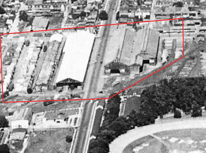
File:1925 - Trexler Lumber Company.jpg

Original file (1,000 × 742 pixels, file size: 130 KB, MIME type: image/jpeg)
Captions
Captions
Summary
[edit]| Description1925 - Trexler Lumber Company.jpg |
English: 1925 - Trexler Lumber Company. Located at 16th and Liberty Streets, Allentown PA. This was a large lumber yard and hardware store, established in 1904 by Harry C. Trexler. Trexler's father Edwin and Edwin's brothers in 1856 had opened the business in the 900 block of Hamilton Street, but as Allentown grew, they moved it to the then vacant west end of Allentown.
A 1937 ad for Trexler Lumber noted that it was one of the largest lumber yards of its kind in the eastern United States. Its roofed lumber shed was called the largest of its kind in the world. Beginning in the early 1960s, the area between Liberty and Allen streets, from 16th to 17th was sold and the large lumber shed torn down. It became a mixed-use area of medical offices, a shopping center and other small buisnesses. The area to the right (South) remained a lumber yard until the night of March 31, 1973, there was a major fire at the Trexler lumber yard that destroyed the remainder of the property along with the C.Y. Schelly & Brothers building. On Sept. 25, 1973, the Charles Kline Lodge of Allentown's B'nai B'rith purchased the destroyed lumber yard for $70,000, cleared the land and constructed what are now are the twelve -story B'nai B'rith Apartments on the site. |
| Date | |
| Source | Unknown photographer |
| Author | Unknown authorUnknown author |
| Permission (Reusing this file) |
This is a digital scan of a photograph that was originally created and published in the United States before 1977 and offered for public sale without a copyright notice and without information of whom the original photographer was |
Licensing
[edit]| Public domainPublic domainfalsefalse |
This work is in the public domain in the United States because it was published in the United States between 1929 and 1977, inclusive, without a copyright notice. For further explanation, see Commons:Hirtle chart as well as a detailed definition of "publication" for public art.
Note that it may still be copyrighted in jurisdictions that do not apply the rule of the shorter term for US works (depending on the date of the author's death), such as Canada (50 p.m.a.), Mainland China (50 p.m.a., not Hong Kong or Macao), Germany (70 p.m.a.), Mexico (100 p.m.a.), Switzerland (70 p.m.a.), and other countries with individual treaties. العربية ∙ беларуская (тарашкевіца) ∙ čeština ∙ Deutsch ∙ Ελληνικά ∙ English ∙ español ∙ français ∙ Bahasa Indonesia ∙ italiano ∙ 日本語 ∙ 한국어 ∙ македонски ∙ Nederlands ∙ português ∙ русский ∙ sicilianu ∙ slovenščina ∙ ไทย ∙ Tiếng Việt ∙ 中文(简体) ∙ 中文(繁體) ∙ +/− |
| Camera location | 40° 36′ 13″ N, 75° 29′ 40″ W | View this and other nearby images on: OpenStreetMap |
|---|
File history
Click on a date/time to view the file as it appeared at that time.
| Date/Time | Thumbnail | Dimensions | User | Comment | |
|---|---|---|---|---|---|
| current | 22:45, 6 March 2015 |  | 1,000 × 742 (130 KB) | Connor7617 (talk | contribs) | User created page with UploadWizard |
You cannot overwrite this file.
File usage on Commons
There are no pages that use this file.
