File:1878 Adams Monumental Illustrated Panorama of History - Geographicus - WorldHistory-adams-1871.jpg
Jump to navigation
Jump to search

Size of this preview: 800 × 339 pixels. Other resolutions: 320 × 136 pixels | 640 × 271 pixels | 1,024 × 434 pixels | 1,280 × 542 pixels | 2,560 × 1,084 pixels | 10,000 × 4,235 pixels.
Original file (10,000 × 4,235 pixels, file size: 14.71 MB, MIME type: image/jpeg)
Captions
Captions
Add a one-line explanation of what this file represents
| Adams' Illustrated Panorama of History. | ||||||
|---|---|---|---|---|---|---|
| Artist | ||||||
| Title |
Adams' Illustrated Panorama of History. |
|||||
| Description |
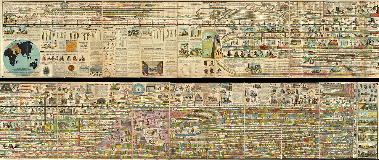
English: A truly monumental achievement, this is Adams' Illustrated Panorama of History . Measuring some 27 inches high and 260 inches long, this gigantic panoramic diagram charts the history of the world from a Biblical perspective, starting with the creation of Adam in 4004 B.C. and ending in 1878 (though projected into the future as far as 1900). Adams centers his chart on the Stream of Time which is divided into decades and centuries. Initially he simply follows the Bible's begats, but eventually he slowly segues into the historical period with the development of Egyptian, Persian, and Greek culture. He notes all important events and offers historical and biblical commentary where appropriate - often illustrating historical monuments and Biblical events and monstrosities. Eventually the map gets necessarily more and more complicated as it passes into the classical era, the pre modern era, and ultimately the modern times. At the end of the chart Adams shows the currently reigning world rulers, discusses the development of the United States, and even offers a breakdown of historically important technological developments. Adams' also interestingly attempts to reconcile Biblical with Global history, associating for example, Noah, with Yao, a legendary figure in early Chinese mythology. This chart is so rich in detail and information that it is all but impossible to fully give it credit here, however, we encourage you to use the zoom engine above to thoroughly appreciate this remarkable document. The amazing chart was drawn by Sebastian C. Adams of Salem, Oregon. This is the third edition, the first having been published in 1871. The chart was published by A. H. Walker, a prominent European publisher with offices in London and Paris. Printed in the United States by Strobridge & Co, lithographers of Cincinnati, Ohio. Extremely rare. |
|||||
| Date | 1878 (dated) | |||||
| Dimensions | height: 27 in (68.5 cm); width: 260 in (660.4 cm) | |||||
| Accession number |
Geographicus link: WorldHistory-adams-1871 |
|||||
| Source/Photographer |
|
|||||
| Permission (Reusing this file) |
|
|||||
File history
Click on a date/time to view the file as it appeared at that time.
| Date/Time | Thumbnail | Dimensions | User | Comment | |
|---|---|---|---|---|---|
| current | 13:13, 24 March 2011 | | 10,000 × 4,235 (14.71 MB) | BotMultichillT (talk | contribs) | {{subst:User:Multichill/Geographicus |link=http://www.geographicus.com/P/AntiqueMap/WorldHistory-adams-1871 |product_name=1878 Adams Monumental Illustrated Panorama of History |map_title=Adams' Illustrated Panorama of History. |description=A truly monumen |
You cannot overwrite this file.
File usage on Commons
The following 3 pages use this file:
File usage on other wikis
The following other wikis use this file:
- Usage on fr.wikipedia.org
- Usage on no.wikipedia.org