File:1831 Félix Delamarche map of the United Kingdom of the Netherlands.jpg
From Wikimedia Commons, the free media repository
Jump to navigation
Jump to search

Size of this preview: 433 × 599 pixels. Other resolutions: 173 × 240 pixels | 347 × 480 pixels | 555 × 768 pixels | 740 × 1,024 pixels | 2,168 × 3,000 pixels.
Original file (2,168 × 3,000 pixels, file size: 1.51 MB, MIME type: image/jpeg)
File information
Structured data
Captions
Captions
Add a one-line explanation of what this file represents
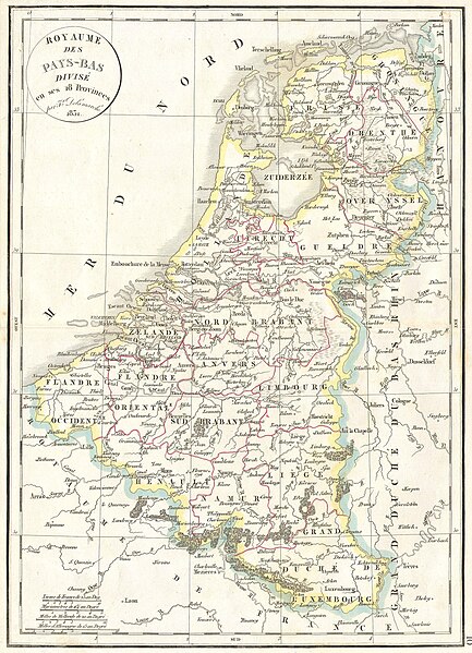
| Royaume des Pays-bas divise en ses 18 Provinces. | |||||||
|---|---|---|---|---|---|---|---|
| Artist |
Félix Delamarche (1779–1835) |
||||||
| Title |
Royaume des Pays-bas divise en ses 18 Provinces. |
||||||
| Description |
English: This hand colored map is a copper plate engraving, dating to 1831 by Félix Delamarche (1779–1835), son of the well-known French mapmaker Charles François Delamarche (1740–1817). It is a representation of the United Kingdom of the Netherlands, that was at that time going through the Belgian Revolution (1830–1839) that would lead it to split up in the Netherlands ('Holland') in the north and Belgium in the south. |
||||||
| Date |
1831 date QS:P571,+1831-00-00T00:00:00Z/9 |
||||||
| Dimensions |
height: 12 in (30.4 cm); width: 17 in (43.1 cm) dimensions QS:P2048,12U218593 dimensions QS:P2049,17U218593 |
||||||
| Accession number |
Geographicus link: HollandBelgium-d-32 |
||||||
| Source/Photographer |
|
||||||
| Permission (Reusing this file) |
|
||||||
File history
Click on a date/time to view the file as it appeared at that time.
| Date/Time | Thumbnail | Dimensions | User | Comment | |
|---|---|---|---|---|---|
| current | 11:36, 16 March 2011 |  | 2,168 × 3,000 (1.51 MB) | BotMultichill (talk | contribs) | {{subst:User:Multichill/Geographicus |link=http://www.geographicus.com/P/AntiqueMap/HollandBelgium-d-32 |product_name=1832 Delamarche Map of Holland and Belgium |map_title=Royaume des Pays-bas divise en ses 18 Provinces. |description=This hand colored map |
You cannot overwrite this file.
File usage on Commons
The following 2 pages use this file: