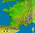
File:1800x1730-France-Découpe-Relief.jpg
From Wikimedia Commons, the free media repository
Jump to navigation
Jump to search

Size of this preview: 624 × 600 pixels. Other resolutions: 250 × 240 pixels | 499 × 480 pixels | 799 × 768 pixels | 1,065 × 1,024 pixels | 1,800 × 1,730 pixels.
Original file (1,800 × 1,730 pixels, file size: 797 KB, MIME type: image/jpeg)
File information
Structured data
Captions
Captions
Add a one-line explanation of what this file represents
| Description1800x1730-France-Découpe-Relief.jpg |
Français : *Carte France Nasa Radar SRTM
|
||
| Date | |||
| Source | NASA Radar SRTM | ||
| Author | Wikisoft* @@@-fr 08:16, 25 August 2011 (UTC) | ||
| Permission (Reusing this file) |
This file is licensed under the Creative Commons Attribution-Share Alike 1.0 Generic license.
|
||
| Other versions | France |
Redimenssionnée pour fr:Modèle:Géolocalisation/France
File history
Click on a date/time to view the file as it appeared at that time.
| Date/Time | Thumbnail | Dimensions | User | Comment | |
|---|---|---|---|---|---|
| current | 09:57, 14 January 2013 |  | 1,800 × 1,730 (797 KB) | Wikisoft* (talk | contribs) | Améliorations divers |
| 08:16, 25 August 2011 |  | 1,800 × 1,730 (1.13 MB) | Wikisoft* (talk | contribs) | {{Information |Description ={{fr|1=*Carte France Nasa Radar SRTM *Redimenssionnée et complétée par Wikisoft* Travail personnel}} |Source =NASA Radar SRTM |Author =~~~~ |Date =25 08 2011 |Permission ={{GFCL}}{{CC-BY- |
You cannot overwrite this file.
File usage on Commons
There are no pages that use this file.
File usage on other wikis
The following other wikis use this file:
- Usage on fr.wikipedia.org
