File:1632 Cardona Descripcion Indias (33).jpg
From Wikimedia Commons, the free media repository
Jump to navigation
Jump to search

Size of this preview: 800 × 524 pixels. Other resolutions: 320 × 209 pixels | 640 × 419 pixels | 1,024 × 670 pixels | 1,280 × 838 pixels | 3,072 × 2,011 pixels.
Original file (3,072 × 2,011 pixels, file size: 578 KB, MIME type: image/jpeg)
File information
Structured data
Captions
Captions
Add a one-line explanation of what this file represents
Summary
[edit]| Description1632 Cardona Descripcion Indias (33).jpg |
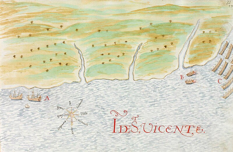
Español: Isla de San Vicente. Piraguas caribes (C) atacan por sorpresa a dos barcas españolas (B) con las que habían acordado comerciar. Página 33 de las Descripciones geográficas e hidrográficas de muchas tierras y mares del Norte y Sur en las Indias, en especial del descubrimiento del Reino de la California redactadas por el capitán Nicolás de Cardona tras su expedición de 1614.
English: Saint Vincent island. Carib pirogues (B) attack by surprise two Spanish boats (B) with whom they had agreed to trade. Page 33 of the Descripciones geográficas e hidrográficas de muchas tierras y mares del Norte y Sur en las Indias, en especial del descubrimiento del Reino de la California (Geographic and hydrographic descriptions of many northern and southern lands and seas in the Indies, specifically the discovery of the kingdom of California), written by captain Nicolás de Cardona after his expedition of 1614. |
|||||||||||||||||||
| Date | ||||||||||||||||||||
| Source |
Descripciones geográficas e hidrográficas de muchas tierras y mares del Norte y Sur en las Indias, en especial del descubrimiento del Reino de California hecho con trabajo e industria por el capitán y cabo Nicolás de Cardona ... dirigidas al Exmo. D. Gaspar de Guzmán, Conde de Olivares ... Biblioteca Digital Hispánica (Biblioteca Nacional de España) |
|||||||||||||||||||
| Author |
creator QS:P170,Q2395824 |
|||||||||||||||||||
Licensing
[edit]|
This is a faithful photographic reproduction of a two-dimensional, public domain work of art. The work of art itself is in the public domain for the following reason:
The official position taken by the Wikimedia Foundation is that "faithful reproductions of two-dimensional public domain works of art are public domain".
This photographic reproduction is therefore also considered to be in the public domain in the United States. In other jurisdictions, re-use of this content may be restricted; see Reuse of PD-Art photographs for details. | |||||
File history
Click on a date/time to view the file as it appeared at that time.
| Date/Time | Thumbnail | Dimensions | User | Comment | |
|---|---|---|---|---|---|
| current | 20:13, 19 September 2023 |  | 3,072 × 2,011 (578 KB) | Beao (talk | contribs) | Cropped 4 % horizontally, 7 % vertically using CropTool with lossless mode. Removed watermark. |
| 23:29, 5 March 2016 |  | 3,184 × 2,165 (666 KB) | Hispalois (talk | contribs) | User created page with UploadWizard |
You cannot overwrite this file.
File usage on Commons
The following page uses this file:
File usage on other wikis
The following other wikis use this file:
- Usage on bn.wikipedia.org
- Usage on en.wikipedia.org
- Usage on es.wikipedia.org
- Usage on fi.wikipedia.org
- Usage on he.wikipedia.org
Structured data
Items portrayed in this file
depicts
24 June 1632Gregorian
image/jpeg
d4ed0e9f7ceb8d5fe46405bb52665b080b5e07df
591,515 byte
2,011 pixel
3,072 pixel
Categories:
- Descripciones geográficas e hidrográficas de muchas tierras y mares del Norte y Sur en las Indias, en especial del descubrimiento del Reino de la California
- Maps by Nicolás de Cardona
- Watercolor maps
- 1632 maps
- Old manuscript maps
- History of Saint Vincent and the Grenadines
- Maps of battles of Spain
- 1632 in the Caribbean
Hidden categories: