File:新竹驛.jpg
Original file (4,032 × 3,024 pixels, file size: 2.04 MB, MIME type: image/jpeg)
Captions
Summary
[edit]Description新竹驛.jpg |
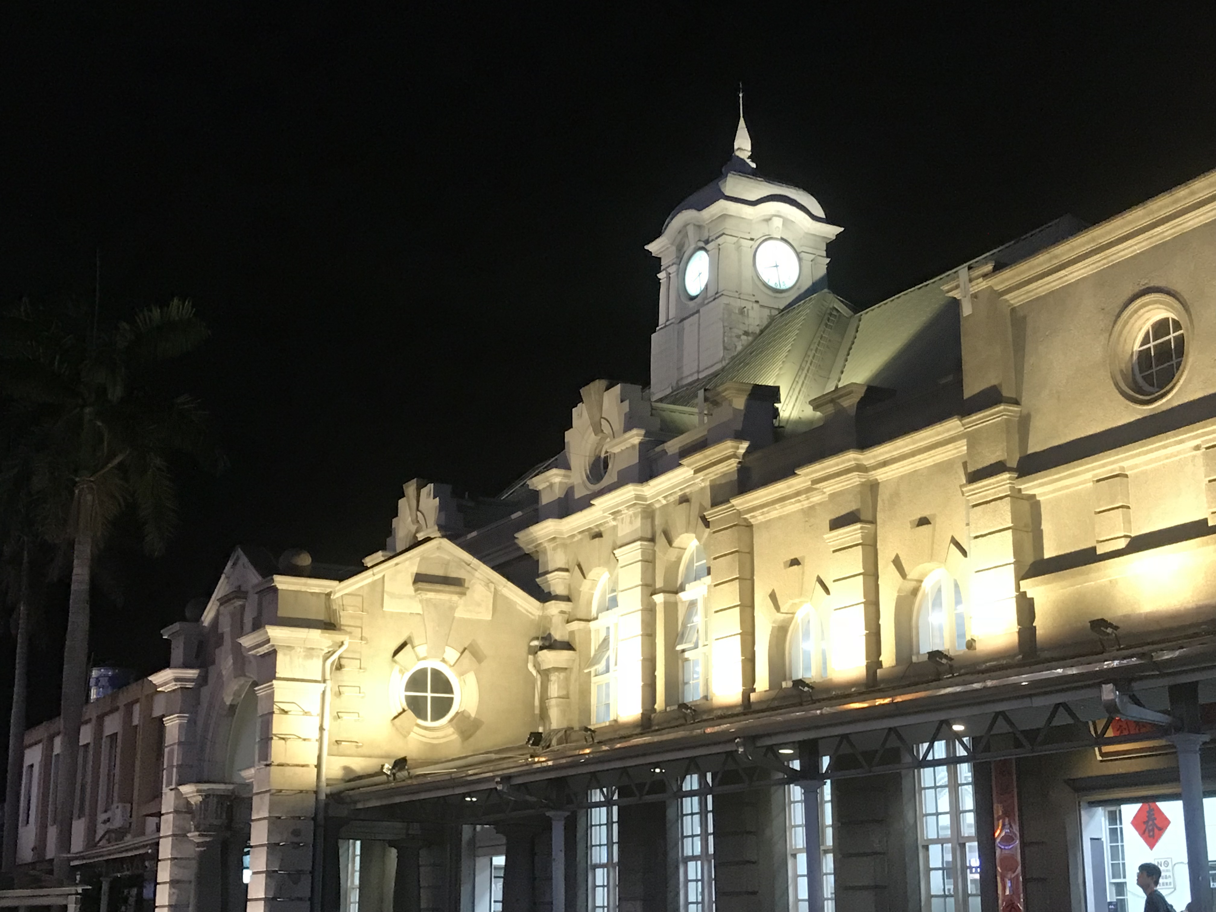
中文:站體建築樣式結合了巴洛克風格與德式哥德風,具有陡斜的屋頂,為整個車站帶來優美典雅的異國情調,加上厚實的紅磚牆壁,讓設計繁複的建築更顯莊重,線條分明的設計點綴著細緻的裝飾。二戰後整修的樣子與原設計較不同。是臺灣最古老的現役站房,為國定古蹟。 |
Date | |
Source | Own work |
Author | Kwiyomi |
Camera location | 24° 48′ 05.58″ N, 120° 58′ 16.84″ E | View this and other nearby images on: OpenStreetMap | 24.801550; 120.971344 |
---|
Licensing
[edit]- You are free:
- to share – to copy, distribute and transmit the work
- to remix – to adapt the work
- Under the following conditions:
- attribution – You must give appropriate credit, provide a link to the license, and indicate if changes were made. You may do so in any reasonable manner, but not in any way that suggests the licensor endorses you or your use.
- share alike – If you remix, transform, or build upon the material, you must distribute your contributions under the same or compatible license as the original.
This image was uploaded as part of Wiki Loves Monuments 2019.
Afrikaans ∙ Alemannisch ∙ العربية ∙ جازايرية ∙ azərbaycanca ∙ Bikol Central ∙ беларуская ∙ беларуская (тарашкевіца) ∙ български ∙ বাংলা ∙ brezhoneg ∙ bosanski ∙ català ∙ čeština ∙ Cymraeg ∙ dansk ∙ Deutsch ∙ Zazaki ∙ Ελληνικά ∙ English ∙ Esperanto ∙ español ∙ eesti ∙ euskara ∙ فارسی ∙ suomi ∙ français ∙ Frysk ∙ Gaeilge ∙ galego ∙ עברית ∙ हिन्दी ∙ hrvatski ∙ magyar ∙ հայերեն ∙ Bahasa Indonesia ∙ Ido ∙ italiano ∙ 日本語 ∙ ქართული ∙ 한국어 ∙ кыргызча ∙ Lëtzebuergesch ∙ latviešu ∙ Malagasy ∙ македонски ∙ മലയാളം ∙ Bahasa Melayu ∙ Malti ∙ norsk bokmål ∙ नेपाली ∙ Nederlands ∙ norsk nynorsk ∙ norsk ∙ polski ∙ português ∙ português do Brasil ∙ română ∙ русский ∙ sicilianu ∙ davvisámegiella ∙ slovenčina ∙ slovenščina ∙ shqip ∙ српски / srpski ∙ svenska ∙ ไทย ∙ Tagalog ∙ Türkçe ∙ українська ∙ اردو ∙ oʻzbekcha / ўзбекча ∙ Yorùbá ∙ 中文 ∙ 中文(中国大陆) ∙ 中文(简体) ∙ 中文(繁體) ∙ 中文(香港) ∙ 中文(臺灣) ∙ +/− |
File history
Click on a date/time to view the file as it appeared at that time.
Date/Time | Thumbnail | Dimensions | User | Comment | |
---|---|---|---|---|---|
current | 17:41, 18 September 2019 | 4,032 × 3,024 (2.04 MB) | Kwiyomi (talk | contribs) | User created page with UploadWizard |
You cannot overwrite this file.
File usage on Commons
There are no pages that use this file.
Metadata
This file contains additional information such as Exif metadata which may have been added by the digital camera, scanner, or software program used to create or digitize it. If the file has been modified from its original state, some details such as the timestamp may not fully reflect those of the original file. The timestamp is only as accurate as the clock in the camera, and it may be completely wrong.
Camera manufacturer | Apple |
---|---|
Camera model | iPhone 7 Plus |
Exposure time | 1/15 sec (0.066666666666667) |
F-number | f/1.8 |
ISO speed rating | 64 |
Date and time of data generation | 20:28, 24 July 2018 |
Lens focal length | 3.99 mm |
Latitude | 24° 48′ 5.58″ N |
Longitude | 120° 58′ 16.84″ E |
Altitude | 45.916 meters above sea level |
Orientation | Normal |
Horizontal resolution | 72 dpi |
Vertical resolution | 72 dpi |
Software used | 11.4 |
File change date and time | 20:28, 24 July 2018 |
Y and C positioning | Centered |
Exposure Program | Normal program |
Exif version | 2.21 |
Date and time of digitizing | 20:28, 24 July 2018 |
Meaning of each component |
|
APEX shutter speed | 3.908507223114 |
APEX aperture | 1.6959937156324 |
APEX brightness | 1.3502358490566 |
APEX exposure bias | 0 |
Metering mode | Pattern |
Flash | Flash did not fire, auto mode |
DateTimeOriginal subseconds | 053 |
DateTimeDigitized subseconds | 053 |
Supported Flashpix version | 1 |
Color space | Uncalibrated |
Sensing method | One-chip color area sensor |
Scene type | A directly photographed image |
Exposure mode | Auto exposure |
White balance | Auto white balance |
Digital zoom ratio | 1.8666666666667 |
Focal length in 35 mm film | 59 mm |
Scene capture type | Standard |
GPS time (atomic clock) | 12:28 |
Speed unit | Kilometers per hour |
Speed of GPS receiver | 0.029613676134069 |
Reference for direction of image | True direction |
Direction of image | 74.516447368421 |
Reference for bearing of destination | True direction |
Bearing of destination | 74.516447368421 |
GPS date | 24 July 2018 |
Structured data
Items portrayed in this file
depicts
24°48'5.580"N, 120°58'16.838"E
24 July 2018
0.06666666666666666666 second
1.8
3.99 millimetre
image/jpeg
- Files with coordinates missing SDC location of creation
- CC-BY-SA-4.0
- Self-published work
- Images from Wiki Loves Monuments 2019
- Images from Wiki Loves Monuments 2019 in Taiwan
- Images from Wiki Loves Monuments missing SDC depicts
- Images from Wiki Loves Monuments missing SDC location of creation
- Uploaded via Campaign:wlm-tw
- Checked Images of WLM 2019 in Taiwan
- Taiwan photographs taken on 2018-07-24