File:崇仁新村.jpg
Original file (5,664 × 3,184 pixels, file size: 4.52 MB, MIME type: image/jpeg)
Captions
Summary
[edit]Description崇仁新村.jpg |
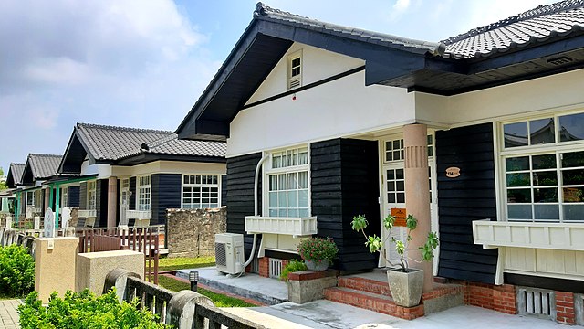
中文(繁體):1920年,日治政府在下淡水溪沿岸興建屏北飛行場,擔任防空作戰,並作為警察航空班基地。過了幾年,日本以台灣為南進基地,原駐紮於日本九州福岡太刀洗的陸軍飛行第八聯隊移防至屏東,大批官舍陸續在屏北地區出現,即現今的崇仁新村。1936年,陸軍飛行第八聯隊擴編為陸軍第三飛行團,於現在中山路與青島街一帶新蓋「崇蘭陸軍官舍群」(今勝利新村)。光復後,日軍離去,改由國軍空軍第六聯隊進駐,逐步擴建,占地愈見廣闊。在全台眷村幾乎拆除殆盡的同時,勝利新村及崇仁新村(成功區)計71 幢在屏東縣政府的奔走下,登錄為屏東縣歷史建築,幸運地被保留下來。 |
Date | |
Source | Own work |
Author | WEI, WAN-CHEN(魏琬臻) |
Camera location | 22° 40′ 27″ N, 120° 29′ 03″ E | View this and other nearby images on: OpenStreetMap | 22.674167; 120.484167 |
---|
Licensing
[edit]- You are free:
- to share – to copy, distribute and transmit the work
- to remix – to adapt the work
- Under the following conditions:
- attribution – You must give appropriate credit, provide a link to the license, and indicate if changes were made. You may do so in any reasonable manner, but not in any way that suggests the licensor endorses you or your use.
- share alike – If you remix, transform, or build upon the material, you must distribute your contributions under the same or compatible license as the original.
This image was uploaded as part of Wiki Loves Monuments 2022.
Afrikaans ∙ Alemannisch ∙ العربية ∙ جازايرية ∙ azərbaycanca ∙ Bikol Central ∙ беларуская ∙ беларуская (тарашкевіца) ∙ български ∙ বাংলা ∙ brezhoneg ∙ bosanski ∙ català ∙ čeština ∙ Cymraeg ∙ dansk ∙ Deutsch ∙ Zazaki ∙ Ελληνικά ∙ English ∙ Esperanto ∙ español ∙ eesti ∙ euskara ∙ فارسی ∙ suomi ∙ français ∙ Frysk ∙ Gaeilge ∙ galego ∙ עברית ∙ हिन्दी ∙ hrvatski ∙ magyar ∙ հայերեն ∙ Bahasa Indonesia ∙ Ido ∙ italiano ∙ 日本語 ∙ ქართული ∙ 한국어 ∙ кыргызча ∙ Lëtzebuergesch ∙ latviešu ∙ Malagasy ∙ македонски ∙ മലയാളം ∙ Bahasa Melayu ∙ Malti ∙ norsk bokmål ∙ नेपाली ∙ Nederlands ∙ norsk nynorsk ∙ norsk ∙ polski ∙ português ∙ português do Brasil ∙ română ∙ русский ∙ sicilianu ∙ davvisámegiella ∙ slovenčina ∙ slovenščina ∙ shqip ∙ српски / srpski ∙ svenska ∙ ไทย ∙ Tagalog ∙ Türkçe ∙ українська ∙ اردو ∙ oʻzbekcha / ўзбекча ∙ Yorùbá ∙ 中文 ∙ 中文(中国大陆) ∙ 中文(简体) ∙ 中文(繁體) ∙ 中文(香港) ∙ 中文(臺灣) ∙ +/− |
File history
Click on a date/time to view the file as it appeared at that time.
Date/Time | Thumbnail | Dimensions | User | Comment | |
---|---|---|---|---|---|
current | 01:18, 24 September 2022 | 5,664 × 3,184 (4.52 MB) | WEI, WAN-CHEN (talk | contribs) | Uploaded own work with UploadWizard |
You cannot overwrite this file.
File usage on Commons
There are no pages that use this file.
Metadata
This file contains additional information such as Exif metadata which may have been added by the digital camera, scanner, or software program used to create or digitize it. If the file has been modified from its original state, some details such as the timestamp may not fully reflect those of the original file. The timestamp is only as accurate as the clock in the camera, and it may be completely wrong.
Camera manufacturer | samsung |
---|---|
Camera model | SM-A750GN |
Date and time of data generation | 12:47, 9 September 2022 |
Exposure time | 1/1,018 sec (0.00098231827111984) |
F-number | f/1.7 |
ISO speed rating | 40 |
Lens focal length | 3.93 mm |
Latitude | 22° 40′ 27″ N |
Altitude | 47 meters above sea level |
Longitude | 120° 29′ 3″ E |
Height | 3,184 px |
Orientation | 0 |
File change date and time | 10:27, 11 September 2022 |
Vertical resolution | 72 dpi |
Horizontal resolution | 72 dpi |
Width | 5,664 px |
Software used | A750GNDXS6CTE1 |
Y and C positioning | Centered |
APEX aperture | 1.53 |
Scene type | A directly photographed image |
Exif version | 2.2 |
APEX exposure bias | 0 |
Exposure Program | Normal program |
Unique image ID | B24LSLF01AM B24LSNC04AA |
Color space | sRGB |
Maximum land aperture | 1.53 APEX (f/1.7) |
APEX brightness | 8.36 |
Supported Flashpix version | 1 |
DateTimeOriginal subseconds | 0228 |
White balance | Auto white balance |
Custom image processing | Normal process |
Exposure mode | Auto exposure |
Flash | Flash did not fire |
DateTime subseconds | 0228 |
Saturation | Normal |
Meaning of each component |
|
Focal length in 35 mm film | 27 mm |
DateTimeDigitized subseconds | 0228 |
Sharpness | Normal |
Contrast | Normal |
Date and time of digitizing | 12:47, 9 September 2022 |
APEX shutter speed | 10.99 |
Metering mode | Center weighted average |
Scene capture type | Standard |
Light source | Unknown |
GPS time (atomic clock) | 04:47 |
GPS date | 9 September 2022 |
GPS tag version | 2.2.0.0 |
Structured data
Items portrayed in this file
depicts
some value
9 September 2022
22°40'27.001"N, 120°29'3.001"E
0.00098231827111984282 second
1.7
3.93 millimetre
image/jpeg
- Files with coordinates missing SDC location of creation
- CC-BY-SA-4.0
- Self-published work
- Images from Wiki Loves Monuments 2022
- Images from Wiki Loves Monuments 2022 in Taiwan
- Images from Wiki Loves Monuments missing SDC depicts
- Images from Wiki Loves Monuments missing SDC location of creation
- Uploaded via Campaign:wlm-tw
- WLM 2022 in Taiwan +