File:Карта Ауховского района и Пригородного района.png
(Redirected from File:Карта спорных территорий.png)
Size of this preview: 588 × 599 pixels. Other resolutions: 235 × 240 pixels | 471 × 480 pixels | 753 × 768 pixels | 1,004 × 1,024 pixels | 2,000 × 2,039 pixels.
Original file (2,000 × 2,039 pixels, file size: 526 KB, MIME type: image/png)
Captions
Captions
Add a one-line explanation of what this file represents

|
File:Карта Ауховского района и Пригородного района.svg is a vector version of this file. It should be used in place of this PNG file when not inferior.
File:Карта Ауховского района и Пригородного района.png → File:Карта Ауховского района и Пригородного района.svg
For more information, see Help:SVG. |
 |
.
Summary
[edit]
| Description |
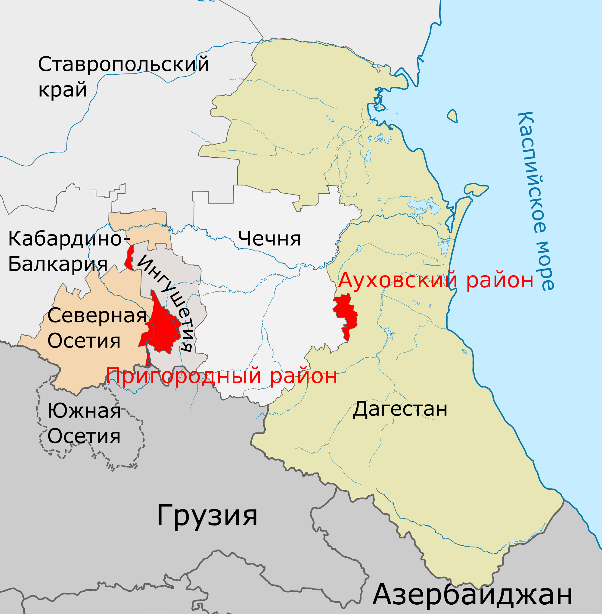
English: Karta Spornyh Territoriy
Русский: Карта Ауховского района и Пригородного района |
| Date | 05 10 2009 |
| Source | Own work |
| Author | Дагиров Умар |
Licensing
[edit]
I, the copyright holder of this work, hereby publish it under the following licenses:

|
Permission is granted to copy, distribute and/or modify this document under the terms of the GNU Free Documentation License, Version 1.2 or any later version published by the Free Software Foundation; with no Invariant Sections, no Front-Cover Texts, and no Back-Cover Texts. A copy of the license is included in the section entitled GNU Free Documentation License. |
This file is licensed under the Creative Commons Attribution-Share Alike 3.0 Unported, 2.5 Generic, 2.0 Generic and 1.0 Generic license.
- You are free:
- to share – to copy, distribute and transmit the work
- to remix – to adapt the work
- Under the following conditions:
- attribution – You must give appropriate credit, provide a link to the license, and indicate if changes were made. You may do so in any reasonable manner, but not in any way that suggests the licensor endorses you or your use.
- share alike – If you remix, transform, or build upon the material, you must distribute your contributions under the same or compatible license as the original.
You may select the license of your choice.
| Annotations | This image is annotated: View the annotations at Commons |
File history
Click on a date/time to view the file as it appeared at that time.
| Date/Time | Thumbnail | Dimensions | User | Comment | |
|---|---|---|---|---|---|
| current | 06:18, 8 April 2023 | | 2,000 × 2,039 (526 KB) | Takhirgeran Umar (talk | contribs) | Reverted to version as of 10:15, 11 February 2021 (UTC) |
| 00:27, 16 July 2022 |  | 561 × 529 (33 KB) | Mailmap (talk | contribs) | Reverted to version as of 11:54, 10 February 2021 (UTC) | |
| 10:15, 11 February 2021 |  | 2,000 × 2,039 (526 KB) | Takhirgeran Umar (talk | contribs) | Файл переименован | |
| 11:54, 10 February 2021 |  | 561 × 529 (33 KB) | LandRussia (talk | contribs) | Reverted to version as of 14:58, 17 June 2019 (UTC) актуальная версия | |
| 04:42, 23 January 2020 |  | 2,000 × 2,039 (526 KB) | Takhirgeran Umar (talk | contribs) | исп | |
| 21:02, 17 January 2020 |  | 2,000 × 2,039 (526 KB) | Takhirgeran Umar (talk | contribs) | об | |
| 20:45, 17 January 2020 |  | 561 × 529 (35 KB) | Takhirgeran Umar (talk | contribs) | Не передавались. Установили границы | |
| 14:58, 17 June 2019 |  | 561 × 529 (33 KB) | LandRussia (talk | contribs) | Новые территории Чечни после передачи территирии Ингушетией не признаются значительной частью населения Ингушетии | |
| 08:34, 24 April 2017 |  | 561 × 529 (35 KB) | Calthinus (talk | contribs) | more useful this way | |
| 06:20, 17 January 2014 |  | 561 × 529 (34 KB) | ArgoDag (talk | contribs) | Reverted to version as of 16:22, 23 January 2011 |
You cannot overwrite this file.
File usage on Commons
The following 4 pages use this file:
File usage on other wikis
The following other wikis use this file:
- Usage on ru.wikipedia.org