File:Wegekreuz Mainz-Ebersheim.jpg
Original file (3,348 × 4,464 pixels, file size: 10.99 MB, MIME type: image/jpeg)
Captions
Summary
[edit]DescriptionWegekreuz Mainz-Ebersheim.jpg |
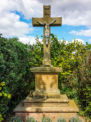
Deutsch: Wegekreuz in Mainz, Stadtteil Ebersheim. Koordinaten 49°54'58"N 8°14'29"E.
Inschrift: Agnus Dei, qui tollis peccata mundi, miserere nobis - Zur Erinnerung an das Fest Kreuzerhöhung 1891English: Wayside Cross near Mainz, Germany. Coordinates: 49°54'58"N 8°14'29"E. This cross was set up to commemorate a Christian fest in 1891. |
Date | |
Source | Own work |
Author | MsMainz |
Openstreetmap entry InfoField | Link to Openstreetmap |
Object location | 49° 54′ 58″ N, 8° 14′ 29″ E | View this and other nearby images on: OpenStreetMap | 49.916121; 8.241380 |
---|
Camera location | 49° 54′ 57.99″ N, 8° 14′ 29.13″ E | View this and other nearby images on: OpenStreetMap | 49.916108; 8.241425 |
---|
Licensing
[edit]- You are free:
- to share – to copy, distribute and transmit the work
- to remix – to adapt the work
- Under the following conditions:
- attribution – You must give appropriate credit, provide a link to the license, and indicate if changes were made. You may do so in any reasonable manner, but not in any way that suggests the licensor endorses you or your use.
- share alike – If you remix, transform, or build upon the material, you must distribute your contributions under the same or compatible license as the original.
This image was uploaded as part of Wiki Loves Monuments 2015.
Afrikaans ∙ Alemannisch ∙ العربية ∙ جازايرية ∙ azərbaycanca ∙ Bikol Central ∙ беларуская ∙ беларуская (тарашкевіца) ∙ български ∙ বাংলা ∙ brezhoneg ∙ bosanski ∙ català ∙ čeština ∙ Cymraeg ∙ dansk ∙ Deutsch ∙ Zazaki ∙ Ελληνικά ∙ English ∙ Esperanto ∙ español ∙ eesti ∙ euskara ∙ فارسی ∙ suomi ∙ français ∙ Frysk ∙ Gaeilge ∙ galego ∙ עברית ∙ हिन्दी ∙ hrvatski ∙ magyar ∙ հայերեն ∙ Bahasa Indonesia ∙ Ido ∙ italiano ∙ 日本語 ∙ ქართული ∙ 한국어 ∙ кыргызча ∙ Lëtzebuergesch ∙ latviešu ∙ Malagasy ∙ македонски ∙ മലയാളം ∙ Bahasa Melayu ∙ Malti ∙ norsk bokmål ∙ नेपाली ∙ Nederlands ∙ norsk nynorsk ∙ norsk ∙ polski ∙ português ∙ português do Brasil ∙ română ∙ русский ∙ sicilianu ∙ davvisámegiella ∙ slovenčina ∙ slovenščina ∙ shqip ∙ српски / srpski ∙ svenska ∙ ไทย ∙ Tagalog ∙ Türkçe ∙ українська ∙ اردو ∙ oʻzbekcha / ўзбекча ∙ Yorùbá ∙ 中文 ∙ 中文(中国大陆) ∙ 中文(简体) ∙ 中文(繁體) ∙ 中文(香港) ∙ 中文(臺灣) ∙ +/− |
File history
Click on a date/time to view the file as it appeared at that time.
Date/Time | Thumbnail | Dimensions | User | Comment | |
---|---|---|---|---|---|
current | 11:33, 10 September 2015 | 3,348 × 4,464 (10.99 MB) | Msmainz (talk | contribs) | User created page with UploadWizard |
You cannot overwrite this file.
File usage on Commons
The following page uses this file:
Metadata
This file contains additional information such as Exif metadata which may have been added by the digital camera, scanner, or software program used to create or digitize it. If the file has been modified from its original state, some details such as the timestamp may not fully reflect those of the original file. The timestamp is only as accurate as the clock in the camera, and it may be completely wrong.
Copyright holder |
|
---|---|
Exposure time | 1/1,150 sec (0.0008695652173913) |
F-number | f/2.2 |
ISO speed rating | 50 |
Date and time of data generation | 13:11, 9 September 2015 |
Lens focal length | 4.2 mm |
User comments | METADATA-START |
Latitude | 49° 54′ 57.99″ N |
Longitude | 8° 14′ 29.13″ E |
Altitude | 225.827 meters above sea level |
Orientation | Normal |
Horizontal resolution | 1.5834531341524 dpi |
Vertical resolution | 45.386666666667 dpi |
File change date and time | 0 (Windows) |
Exposure Program | Normal program |
Exif version | 2.3 |
Date and time of digitizing | 13:11, 9 September 2015 |
APEX shutter speed | 10.167418 |
APEX aperture | 2.275007 |
APEX brightness | 8.37109375 |
APEX exposure bias | 0 |
Maximum land aperture | 2.28 APEX (f/2.2) |
Metering mode | Average |
Light source | Unknown |
Flash | Flash did not fire |
Color space | sRGB |
Sensing method | One-chip color area sensor |
Scene type | A directly photographed image |
Exposure mode | Auto exposure |
White balance | Auto white balance |
Focal length in 35 mm film | 31 mm |
Scene capture type | Standard |
GPS time (atomic clock) | 11:11 |
GPS date | 9 September 2015 |
GPS tag version | 0.0.2.2 |
Software used | Adobe Photoshop Lightroom 6.0 (Windows) |
Date metadata was last modified | 15:02, 10 September 2015 |
Unique ID of original document | 2CA6C8B6344BF47F5AB2BB8B43041116 |
IIM version | 4 |
Structured data
Items portrayed in this file
depicts
9 September 2015
49°54'57.98999"N, 8°14'29.13000"E
49°54'58.03"N, 8°14'28.97"E
Reference
- On OSM
- Files with coordinates missing SDC location of creation (49° N, 8° E)
- CC-BY-SA-4.0
- Self-published work
- Images from Wiki Loves Monuments 2015
- Images from Wiki Loves Monuments 2015 in Germany
- Images from Wiki Loves Monuments missing SDC depicts
- Images from Wiki Loves Monuments missing SDC location of creation
- Images from Wiki Loves Monuments 2015, DE-RP
- Uploaded via Campaign:wlm-de-rp
- Obviously ineligible submissions for Wiki Loves Monuments 2015 in Germany