File:Towns of nejd Arabic.png
Jump to navigation
Jump to search
Size of this preview: 653 × 599 pixels. Other resolutions: 262 × 240 pixels | 523 × 480 pixels | 755 × 693 pixels.
Original file (755 × 693 pixels, file size: 1,019 KB, MIME type: image/png)
Captions
Captions
Add a one-line explanation of what this file represents
Summary
[edit]
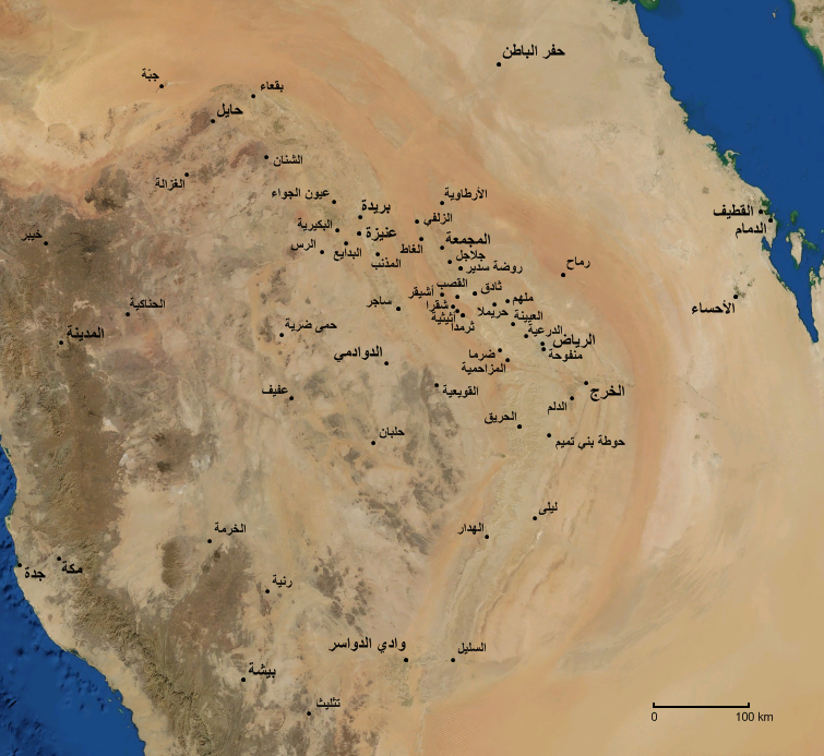
صورة لهضبة نجد بواسطة الأقمار الصناعية و موضح عليها مواقع بعض المدن و القر
ى و الهجر في المنطقة. هجره الثلیماDerived from an image obtained from NASA's WorldWind software.
Licensing
[edit]
| This image is in the public domain because it is a screenshot from NASA’s globe software World Wind using a public domain layer, such as Blue Marble, MODIS, Landsat, SRTM, USGS or GLOBE.
|
 |
File history
Click on a date/time to view the file as it appeared at that time.
| Date/Time | Thumbnail | Dimensions | User | Comment | |
|---|---|---|---|---|---|
| current | 06:12, 24 May 2007 | | 755 × 693 (1,019 KB) | Slackerlawstudent~commonswiki (talk | contribs) | |
| 20:00, 20 May 2007 |  | 755 × 693 (1,019 KB) | Slackerlawstudent~commonswiki (talk | contribs) | ||
| 05:05, 20 May 2007 |  | 755 × 693 (1,019 KB) | Slackerlawstudent~commonswiki (talk | contribs) | ||
| 22:42, 17 May 2007 |  | 912 × 811 (1.41 MB) | Slackerlawstudent~commonswiki (talk | contribs) | ||
| 23:13, 16 May 2007 |  | 912 × 811 (1.41 MB) | Slackerlawstudent~commonswiki (talk | contribs) | ||
| 22:24, 16 May 2007 |  | 912 × 811 (1.41 MB) | Slackerlawstudent~commonswiki (talk | contribs) | ||
| 18:29, 16 May 2007 |  | 912 × 811 (1.4 MB) | Slackerlawstudent~commonswiki (talk | contribs) | أهم المدن و القرى و الهجر الواقعة على هضبة نجد. | |
| 17:52, 16 May 2007 |  | 1,534 × 876 (2.71 MB) | Slackerlawstudent~commonswiki (talk | contribs) | This image was obtained from NASA's WorldWind Program. I modified it by adding the locations of several towns and cities. |
You cannot overwrite this file.
File usage on Commons
There are no pages that use this file.
File usage on other wikis
The following other wikis use this file:
- Usage on ar.wikipedia.org
- Usage on arz.wikipedia.org
- Usage on en.wikipedia.org
- Usage on fa.wikipedia.org