File:TitanicRoute (ru).svg
From Wikimedia Commons, the free media repository
Jump to navigation
Jump to search

Size of this PNG preview of this SVG file: 800 × 332 pixels. Other resolutions: 320 × 133 pixels | 640 × 266 pixels | 1,024 × 425 pixels | 1,280 × 531 pixels | 2,560 × 1,062 pixels.
Original file (SVG file, nominally 800 × 332 pixels, file size: 52 KB)
File information
Structured data
Captions
Captions
Add a one-line explanation of what this file represents
| DescriptionTitanicRoute (ru).svg |
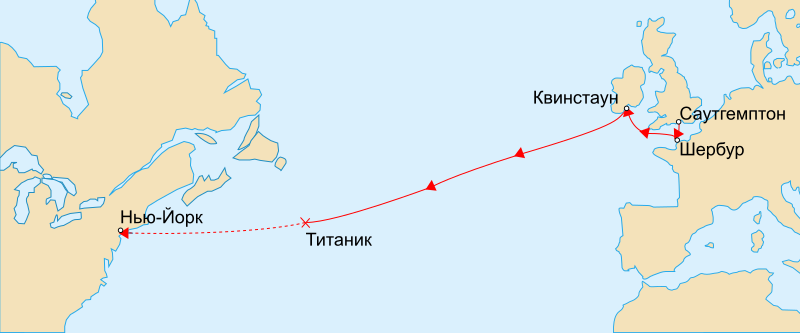
Русский: Карта маршрута первого и единственного плавания парохода "Титаник". Отмечены порты на маршруте, а также место затопления. English: Map marks the route of RMS Titanic during her maiden voyage, the ports on that route, and approximate location of where she sank on 1912-04-15. The remaining portion of her uncompleted route is shown dashed. Français : Version vectorielle de Image:TitanicRoute.png Suomi: RMS Titanicin neitsytmatkan reitti. Yhtenäinen viiva kuvaa toteutunutta reittiä 10.–15. huhtikuuta 1912. Uppoamispaikka on merkitty rastilla ja suunniteltu loppumatka katkoviivalla. |
| Date | (UTC) |
| Source | |
| Author |
|
| This is a retouched picture, which means that it has been digitally altered from its original version. Modifications: Simply translated into russian. The original can be viewed here: TitanicRoute.svg:
|
I, the copyright holder of this work, hereby publish it under the following license:
| Public domainPublic domainfalsefalse |
| I, the copyright holder of this work, release this work into the public domain. This applies worldwide. In some countries this may not be legally possible; if so: I grant anyone the right to use this work for any purpose, without any conditions, unless such conditions are required by law. |
Original upload log
[edit]This image is a derivative work of the following images:
- File:TitanicRoute.svg licensed with PD-self
- 2007-02-25T17:56:09Z Rogilbert 800x332 (69174 Bytes) /*Bords*/
- 2007-02-25T17:53:01Z Rogilbert 800x332 (69168 Bytes) {{Information |Description=Version vectorielle de [[:Image:TitanicRoute.png]]. |Source=[[:Image:TitanicRoute.png]] |Date=~~~~~ |Author=Image originale:[[:en:User:Gary Joseph]], [[:en:User:MechBrowman]] ; image vectorielle:~
Uploaded with derivativeFX
File history
Click on a date/time to view the file as it appeared at that time.
| Date/Time | Thumbnail | Dimensions | User | Comment | |
|---|---|---|---|---|---|
| current | 08:11, 10 December 2010 |  | 800 × 332 (52 KB) | Vasyatka1 (talk | contribs) | {{Information |Description={{ru|Карта маршрута первого и единственного плавания парохода "Титаник". Отмечены порты на маршруте, а также место |
You cannot overwrite this file.
File usage on Commons
There are no pages that use this file.
Metadata
This file contains additional information such as Exif metadata which may have been added by the digital camera, scanner, or software program used to create or digitize it. If the file has been modified from its original state, some details such as the timestamp may not fully reflect those of the original file. The timestamp is only as accurate as the clock in the camera, and it may be completely wrong.
| Width | 800.13px |
|---|---|
| Height | 332.16px |