File:Nsmap.png
Jump to navigation
Jump to search
No higher resolution available.
Nsmap.png (397 × 400 pixels, file size: 36 KB, MIME type: image/png)
Captions
Captions
Add a one-line explanation of what this file represents
Summary
[edit]

|
This file has been superseded by Norfolk Southern Railway system map.svg. It is recommended to use the other file. Please note that deleting superseded images requires consent.
|

|
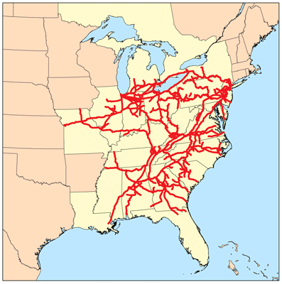
This is a map of the Norfolk Southern Network I made using DOT data.
Licensing
[edit]
I, the copyright holder of this work, hereby publish it under the following license:
This file is licensed under the Creative Commons Attribution-Share Alike 2.5 Generic license.
- You are free:
- to share – to copy, distribute and transmit the work
- to remix – to adapt the work
- Under the following conditions:
- attribution – You must give appropriate credit, provide a link to the license, and indicate if changes were made. You may do so in any reasonable manner, but not in any way that suggests the licensor endorses you or your use.
- share alike – If you remix, transform, or build upon the material, you must distribute your contributions under the same or compatible license as the original.
As an update to the map above: The line from the Iowa border South to the junction with the other lines at Moberly, MO was abandoned in 1997.
File history
Click on a date/time to view the file as it appeared at that time.
| Date/Time | Thumbnail | Dimensions | User | Comment | |
|---|---|---|---|---|---|
| current | 16:34, 14 August 2006 | | 397 × 400 (36 KB) | Kmusser (talk | contribs) | |
| 16:33, 14 August 2006 |  | 397 × 400 (115 KB) | Kmusser (talk | contribs) | This is a map of the Norfolk Southern Network I made using DOT data. Category:Maps == Licensing == {{self|cc-by-sa-2.5}} |
You cannot overwrite this file.
File usage on Commons
There are no pages that use this file.