File:NPS everglades-geologic-map.jpg
Jump to navigation
Jump to search

Size of this preview: 521 × 600 pixels. Other resolutions: 208 × 240 pixels | 417 × 480 pixels | 667 × 768 pixels | 890 × 1,024 pixels | 1,779 × 2,048 pixels | 4,000 × 4,604 pixels.
Original file (4,000 × 4,604 pixels, file size: 4.43 MB, MIME type: image/jpeg)
Captions
Captions
Add a one-line explanation of what this file represents
Summary
[edit]
| Description |
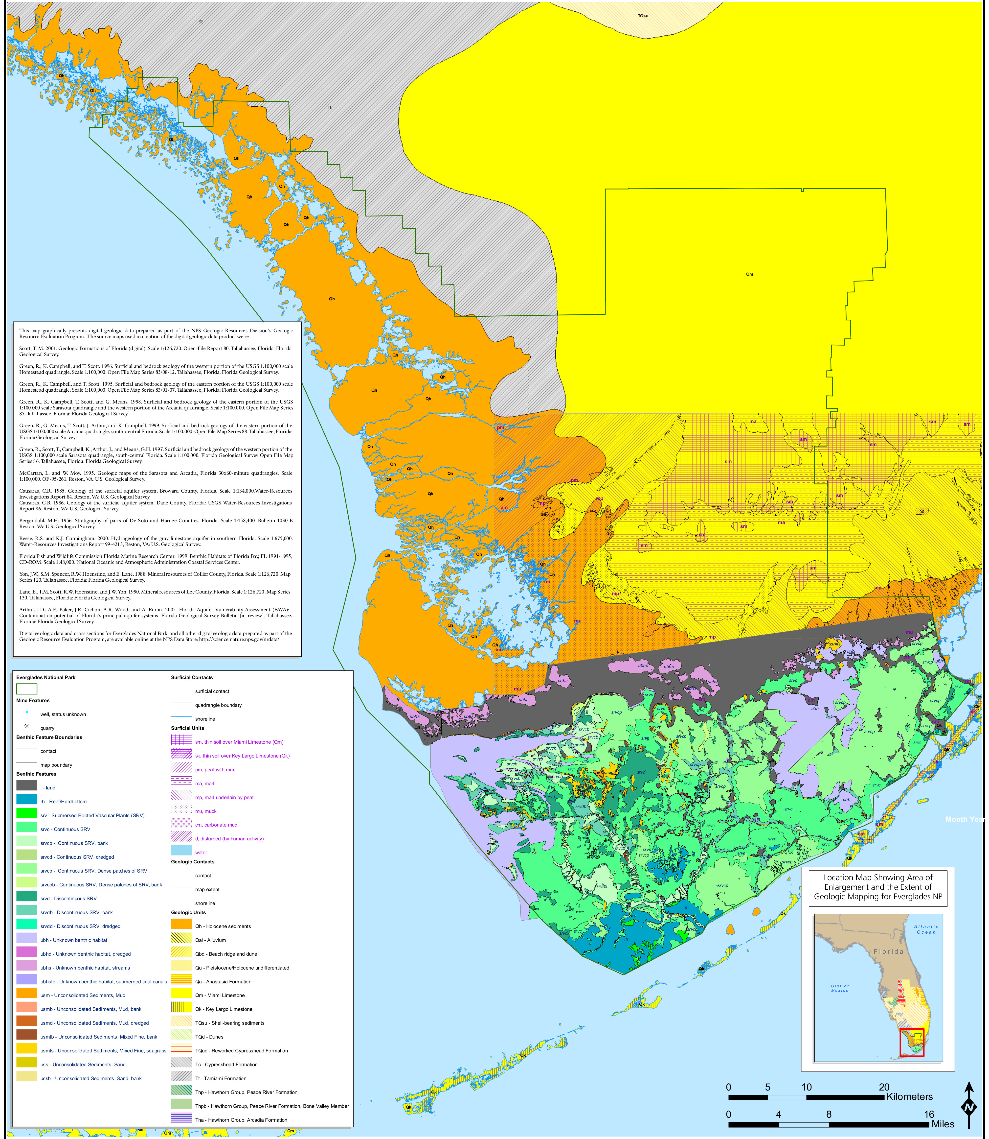
English: This Everglades geologic map shows the rock types as well as plant, vegetation, and water features in and around the national park. |
| Date | |
| Source | U.S. National Park Service (http://npmaps.com/wp-content/uploads/everglades-geologic-map.jpg) |
| Author | U.S. National Park Service, restoration/cleanup by Matt Holly |
Licensing
[edit]
| This image or media file contains material based on a work of a National Park Service employee, created as part of that person's official duties. As a work of the U.S. federal government, such work is in the public domain in the United States. See the NPS website and NPS copyright policy for more information. |
File history
Click on a date/time to view the file as it appeared at that time.
| Date/Time | Thumbnail | Dimensions | User | Comment | |
|---|---|---|---|---|---|
| current | 21:22, 16 May 2017 | | 4,000 × 4,604 (4.43 MB) | RKBot (talk | contribs) | =={{int:filedesc}}== {{Information |description= {{en|1=This crazy, chaotic Everglades geologic map shows the rock types as well as plant, vegetation, and water features in and around the national park.}} |date= 2017-01-20 |source= U.S. National Park S... |
You cannot overwrite this file.
File usage on Commons
There are no pages that use this file.
Categories:
- Geological maps of Everglades National Park
- Geological maps of Florida
- Benthic zones in Florida
- Holocene sediments in Florida
- Quaternary alluvium in Florida
- Quaternary beach ridges and dunes
- Anastasia Formation - maps
- Miami Limestone - maps
- Key Largo Limestone
- Quaternary shell-bearing sediments in Florida
- Neogene shell-bearing sediments in Florida
- Paleogene shell-bearing sediments in Florida
- Neogene dunes in Florida
- Quaternary reworked Cypresshead Formation
- Neogene reworked Cypresshead Formation
- Cypresshead Formation
- Paleogene dunes in Florida
- Tamiami Formation - maps
- Peace River Formation (Florida) - maps
- Bone Valley Formation
- Arcadia Formation (U.S. geology)
- Quaternary soil over Miami Limestone
- Quaternary soil over Key Largo Limestone
- Peat in Florida
- Marl in Florida
- Mud in Florida
- Muck (soil) in Florida
- Benthic maps of Florida