Category:Wenvoe
Jump to navigation
Jump to search
village and community in the Vale of Glamorgan, Wales, UK    | |||||
| Upload media | |||||
| Instance of | |||||
|---|---|---|---|---|---|
| Location | Vale of Glamorgan, Wales | ||||
| Population |
| ||||
| Area |
| ||||
 | |||||
Subcategories
This category has the following 14 subcategories, out of 14 total.
C
- Copthorne Hotel, Cardiff (2 F)
D
O
- Old Port Road, Wenvoe (9 F)
P
- Port Road, Wenvoe (17 F)
S
- St Lythans Road (10 F)
W
- The Wenvoe Arms, Wenvoe (5 F)
- Wenvoe tunnel (9 F)
- Wenvoe War Memorial (5 F)
Media in category "Wenvoe"
The following 200 files are in this category, out of 221 total.
(previous page) (next page)-
 A4226 at Sutton Fach Farm - geograph.org.uk - 5888132.jpg 1,024 × 809; 129 KB
-
 Alps Farm farmhouse - geograph.org.uk - 2170366.jpg 640 × 480; 84 KB
-
 Alps Farm, near Wenvoe - geograph.org.uk - 1819415.jpg 3,296 × 2,472; 1.98 MB
-
 Andrew's Road - geograph.org.uk - 6166009.jpg 1,600 × 900; 519 KB
-
 Approaching the main road - geograph.org.uk - 6166002.jpg 1,600 × 900; 393 KB
-
 Beech Wood - geograph.org.uk - 5461035.jpg 3,264 × 2,448; 3.24 MB
-
 Beware of the Gnomes - geograph.org.uk - 5461293.jpg 3,264 × 2,448; 3.11 MB
-
 Blue sky above Andrew's Roaf - geograph.org.uk - 6166017.jpg 1,600 × 900; 528 KB
-
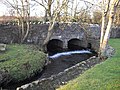 Bridge at Dyffryn Mill - geograph.org.uk - 2244613.jpg 4,000 × 3,000; 3.04 MB
-
 Bridge at Dyffryn Mill - geograph.org.uk - 2244617.jpg 4,000 × 3,000; 2.93 MB
-
 Bridge over dismantled railway - geograph.org.uk - 1819427.jpg 3,296 × 2,472; 1.82 MB
-
 Bridge over dismantled railway, St Andrews Rd, Wenvoe - geograph.org.uk - 1822903.jpg 3,296 × 2,472; 1.92 MB
-
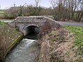 Bridge over the River Waycock - geograph.org.uk - 2771714.jpg 2,200 × 1,650; 4.06 MB
-
 Bungalows, Station Road East, Wenvoe - geograph.org.uk - 2168963.jpg 640 × 480; 54 KB
-
 Burdons Close Playground Wenvoe.jpg 1,200 × 800; 411 KB
-
 Burdonshill, Wenvoe - geograph.org.uk - 1238079.jpg 640 × 425; 97 KB
-
 Burdonshill, Wenvoe. - geograph.org.uk - 383635.jpg 640 × 479; 77 KB
-
 Burdonshill, Wenvoe. - geograph.org.uk - 383641.jpg 640 × 481; 86 KB
-
 Cae y Gwawr - geograph.org.uk - 4896262.jpg 2,394 × 3,191; 1.11 MB
-
 Cemex offices, Wenvoe Quarry - geograph.org.uk - 2176999.jpg 640 × 480; 106 KB
-
 Coed Nant Bran - geograph.org.uk - 5818611.jpg 1,024 × 768; 361 KB
-

-

-
 Cultivated field NE of Wenvoe - geograph.org.uk - 2168999.jpg 640 × 480; 83 KB
-
 Dead sunflowers beside Goldsland Wood - geograph.org.uk - 2242275.jpg 4,000 × 3,000; 3.94 MB
-
 Descent to Alps Farm farmhouse - geograph.org.uk - 2170358.jpg 640 × 480; 98 KB
-
 Dismantled railway near Wenvoe - geograph.org.uk - 3311606.jpg 640 × 480; 38 KB
-
 Disused gateway into Dyffryn Gardens - geograph.org.uk - 2244621.jpg 4,000 × 3,000; 3.45 MB
-
 Disused railway wagons, now disused farm buildings - geograph.org.uk - 2242194.jpg 4,000 × 3,000; 2.52 MB
-
 East edge of Alps Farm - geograph.org.uk - 2170354.jpg 640 × 492; 95 KB
-
 Electricity Pylons - geograph.org.uk - 5461349.jpg 3,264 × 2,448; 1.11 MB
-
 Enclosed footbridge, A4232, Cardiff - geograph.org.uk - 2177499.jpg 640 × 480; 83 KB
-

-
 Entrance to Balas Farm - geograph.org.uk - 1819404.jpg 3,296 × 2,472; 1.97 MB
-
-
 Entrance to Sutton Mawr Farm - geograph.org.uk - 3836930.jpg 2,400 × 1,594; 4.01 MB
-
 Entrance to Wenvoe Quarry - geograph.org.uk - 2089508.jpg 2,816 × 2,112; 1.61 MB
-
 Exhausts Tyres Wenvoe.jpg 1,000 × 750; 295 KB
-
 Farm track near Wenvoe Wood - geograph.org.uk - 2426475.jpg 640 × 480; 114 KB
-
 Farmland near Goldsland Wood - geograph.org.uk - 2242272.jpg 4,000 × 3,000; 3.52 MB
-
 Farmland near Wenvoe - geograph.org.uk - 1819412.jpg 3,296 × 2,472; 1.92 MB
-
 Farmland near Wrinstone Farm - geograph.org.uk - 3311560.jpg 640 × 480; 90 KB
-
 Feeding time, Wenvoe - geograph.org.uk - 2168537.jpg 640 × 480; 93 KB
-

-
 Field next to Maes-y-felin, St Lythans - geograph.org.uk - 5896742.jpg 5,184 × 3,456; 6.91 MB
-

-

-
 Field with St Lythans burial chamber - geograph.org.uk - 2426582.jpg 640 × 480; 107 KB
-
 Fields near Wenvoe - geograph.org.uk - 2089486.jpg 2,816 × 2,112; 1.74 MB
-
 Fields near Wenvoe - geograph.org.uk - 2089510.jpg 2,816 × 2,112; 2 MB
-
 Footbridge across the Nant Brynhill, looking south - geograph.org.uk - 2242286.jpg 4,000 × 3,000; 3.88 MB
-
 Footpath along edge of Coed Nant-bran - geograph.org.uk - 2191932.jpg 640 × 480; 141 KB
-
 Footpath along southern edge of Goldsland Wood - geograph.org.uk - 2242265.jpg 4,000 × 3,000; 3.68 MB
-
 Footpath beside Wrinstons House, near Wenvoe - geograph.org.uk - 2089513.jpg 2,816 × 2,112; 1.89 MB
-
 Footpath in Coed Nant-bran - geograph.org.uk - 3302872.jpg 4,000 × 3,000; 3.62 MB
-
 Footpath in Coed Nant-brân - geograph.org.uk - 2242148.jpg 4,000 × 3,000; 3 MB
-
 Footpath in Coed Nant-brân - geograph.org.uk - 2242160.jpg 4,000 × 3,000; 3.62 MB
-
 Footpath near St Lythans - geograph.org.uk - 2242203.jpg 4,000 × 3,000; 3.26 MB
-

-
 Footpath through Coed Nant-bran - geograph.org.uk - 3302876.jpg 4,000 × 3,000; 4.66 MB
-
 Forgotten forecourt- Wenvoe, south Wales (25822104881).jpg 5,184 × 3,456; 5.36 MB
-

-
 Former railway near Wenvoe - geograph.org.uk - 2089482.jpg 2,112 × 2,816; 2.49 MB
-

-
 Former railway station yard, Wenvoe - geograph.org.uk - 2168850.jpg 640 × 480; 79 KB
-
 Ger - Near Coed y Cymdda Wood - geograph.org.uk - 4387714.jpg 640 × 480; 96 KB
-

-
 Going North on the A4226 - geograph.org.uk - 2771616.jpg 2,000 × 1,489; 1.98 MB
-
 Goldsland Walk Wenvoe.jpg 1,200 × 800; 265 KB
-
 Goldsland Wood - geograph.org.uk - 5461031.jpg 3,264 × 2,448; 3.05 MB
-
 Grange Close, Wenvoe - geograph.org.uk - 2167678.jpg 640 × 497; 76 KB
-
 Great Hamston - geograph.org.uk - 5461025.jpg 3,264 × 2,448; 3.85 MB
-
 Greave Close, Wenvoe - geograph.org.uk - 2167672.jpg 640 × 480; 61 KB
-
 Greave farm, near Wenvoe - geograph.org.uk - 2089491.jpg 2,816 × 2,112; 1.68 MB
-
 Gwenfo - Wenvoe - geograph.org.uk - 4387711.jpg 640 × 480; 87 KB
-

-
 Gypsy Rose - geograph.org.uk - 5263231.jpg 3,264 × 2,448; 2.58 MB
-
 High hedges and mud NE of Wenvoe - geograph.org.uk - 2169021.jpg 640 × 480; 95 KB
-
 House at Whitton - geograph.org.uk - 5263146.jpg 3,264 × 2,448; 2.74 MB
-
 Houses near Wenvoe on Vishwell Road - geograph.org.uk - 2089488.jpg 2,816 × 2,112; 1.62 MB
-

-
 ITV Studios at Culverhouse Cross - geograph.org.uk - 422508.jpg 640 × 480; 139 KB
-

-
 Kissing gate near St Lythans Burial Chamber - geograph.org.uk - 2242239.jpg 4,000 × 3,000; 4.08 MB
-
 Lane at the northern edge of Wenvoe - geograph.org.uk - 2167666.jpg 640 × 480; 90 KB
-
 Lane junction near Wenvoe - geograph.org.uk - 1819419.jpg 3,296 × 2,472; 1.95 MB
-
 Lane near Wenvoe Quarry - geograph.org.uk - 1819406.jpg 3,296 × 2,472; 1.91 MB
-
 Lane north from Wenvoe Quarry - geograph.org.uk - 2176983.jpg 640 × 628; 118 KB
-
 Lane north of Wenvoe Quarry - geograph.org.uk - 2177309.jpg 640 × 480; 102 KB
-
 Lane to Alps Farm - geograph.org.uk - 2170335.jpg 640 × 480; 95 KB
-
 Lane to Wenvoe Quarry - geograph.org.uk - 2177321.jpg 640 × 480; 73 KB
-

-
 Lane west to Wenvoe - geograph.org.uk - 2170329.jpg 640 × 480; 77 KB
-
 Looking towards Burdonshill Farm.jpg 1,600 × 1,200; 601 KB
-
 Looking towards Wenvoe Wood - geograph.org.uk - 2192895.jpg 640 × 480; 82 KB
-
 Looking towards Wenvoe Woods.jpg 1,200 × 900; 421 KB
-
 Minor country road - geograph.org.uk - 6167196.jpg 1,600 × 900; 469 KB
-
 Mock Tudor Houses - geograph.org.uk - 4896289.jpg 3,264 × 2,448; 2.62 MB
-
 Motel - Wenvoe - geograph.org.uk - 4896302.jpg 3,264 × 2,448; 2.32 MB
-

-
 Nant Bran ^ East Lodge, Dyffryn Gardens - geograph.org.uk - 5055999.jpg 5,179 × 3,451; 6.02 MB
-
 New Wallace Farm - geograph.org.uk - 2242285.jpg 4,000 × 3,000; 2.27 MB
-
 New Wallace farm buildings - geograph.org.uk - 2242281.jpg 4,000 × 3,000; 2.5 MB
-
 New Wallace Farmland - geograph.org.uk - 5461032.jpg 3,264 × 2,448; 1.19 MB
-
 No through road^ - geograph.org.uk - 2089494.jpg 2,816 × 2,112; 1.62 MB
-
 North Lodge and entrance to Dyffryn House and Gardens - geograph.org.uk - 5819996.jpg 1,600 × 1,200; 813 KB
-
 Northcliff Farm - geograph.org.uk - 5263152.jpg 3,264 × 2,448; 2.01 MB
-
 Northcliff Stables - geograph.org.uk - 5263227.jpg 3,264 × 2,448; 2.34 MB
-
 Northern arm of Gwenfo Drive, Wenvoe - geograph.org.uk - 2167682.jpg 640 × 548; 75 KB
-
 Old barn at Burdonshill - geograph.org.uk - 2426485.jpg 640 × 480; 87 KB
-

-

-

-
 Old Rectory Wenvoe.jpg 900 × 600; 186 KB
-
 Ordnance Survey Cut Mark - geograph.org.uk - 5709183.jpg 640 × 495; 119 KB
-
 Ordnance Survey Cut Mark - geograph.org.uk - 5709184.jpg 640 × 325; 36 KB
-

-
 Pasture land north of a country lane - geograph.org.uk - 2169005.jpg 640 × 480; 60 KB
-
 Path to gate to field of Gwal y Filiast - geograph.org.uk - 5896693.jpg 5,179 × 3,451; 5.89 MB
-

-
 Play area and picnic area, Dyffryn Gardens - geograph.org.uk - 5820899.jpg 1,200 × 1,600; 919 KB
-
 Port Road roundabout at Caerau Lane - geograph.org.uk - 2222619.jpg 640 × 480; 58 KB
-
 Port Road, Wenvoe - geograph.org.uk - 2167540.jpg 640 × 502; 65 KB
-
 Power Line Insulators - geograph.org.uk - 383626.jpg 640 × 467; 160 KB
-
 Power Line Pylon - geograph.org.uk - 3837438.jpg 1,454 × 2,400; 3.22 MB
-

-
 Power lines near Wenvoe - geograph.org.uk - 1819421.jpg 3,296 × 2,472; 1.91 MB
-
 Power lines to Wrinstone Farm - geograph.org.uk - 1822888.jpg 3,296 × 2,472; 1.93 MB
-
 Premier Inn, Wenvoe - geograph.org.uk - 2167650.jpg 640 × 567; 78 KB
-
 Primary school, Wenvoe - geograph.org.uk - 2168494.jpg 640 × 480; 81 KB
-

-

-
 Pughs Garden Village Wenvoe (1).jpg 1,200 × 800; 452 KB
-
 Pughs Garden Village Wenvoe (2).jpg 1,200 × 800; 435 KB
-
 Pughs Garden Village Wenvoe (3).jpg 1,200 × 800; 435 KB
-
 Pylon beside a country lane junction - geograph.org.uk - 2169104.jpg 480 × 640; 89 KB
-
 Railway Bridge - geograph.org.uk - 4894565.jpg 3,264 × 2,448; 2.38 MB
-

-
 Rectory Close, Wenvoe. - geograph.org.uk - 1156450.jpg 640 × 480; 79 KB
-
 Redundant stile east of Wenvoe - geograph.org.uk - 3311549.jpg 640 × 480; 96 KB
-
 Road from Wenvoe Quarry to the A4050 - geograph.org.uk - 2177007.jpg 640 × 480; 91 KB
-
 Road Junction on to the A4226 - geograph.org.uk - 2771623.jpg 2,000 × 1,500; 2.85 MB
-
 Roundabout Junction of the A4050 and A4231 - geograph.org.uk - 3837483.jpg 2,400 × 1,589; 3.34 MB
-
 Shopping Centre at Culverhouse Cross - geograph.org.uk - 5336306.jpg 1,024 × 729; 130 KB
-
 Side entrance gates to Wenvoe Quarry - geograph.org.uk - 2177296.jpg 640 × 480; 117 KB
-
 Signage for Brooklands Retail Park - geograph.org.uk - 5819830.jpg 1,600 × 1,200; 751 KB
-
 Small ploughed field near Burdonshill - geograph.org.uk - 2426520.jpg 640 × 480; 116 KB
-
 Snowy fields near St Lythans - geograph.org.uk - 3302925.jpg 4,000 × 3,000; 3.14 MB
-
 Southern arm of Gwenfo Drive, Wenvoe - geograph.org.uk - 2167688.jpg 640 × 480; 81 KB
-
 Springfield Close, Wenvoe - geograph.org.uk - 2167936.jpg 640 × 480; 86 KB
-
 Springfield Stores Wenvoe.jpg 1,200 × 900; 354 KB
-
 St.Lythans Court - geograph.org.uk - 4911921.jpg 3,264 × 2,448; 2.26 MB
-

-
 Station Road East, Wenvoe - geograph.org.uk - 2168554.jpg 640 × 480; 67 KB
-
 Station Road East, Wenvoe - geograph.org.uk - 2168809.jpg 640 × 480; 117 KB
-
 Stile at the eastern edge of Coed Nant-brân - geograph.org.uk - 2242164.jpg 4,000 × 3,000; 3.22 MB
-
 Stile beside Lodge House Farm - geograph.org.uk - 2242177.jpg 4,000 × 3,000; 3.72 MB
-
 Stile into Coed Nant-brân - geograph.org.uk - 2242124.jpg 4,000 × 3,000; 3.95 MB
-
 Stile near Alps Farm, Wenvoe - geograph.org.uk - 1819417.jpg 3,296 × 2,472; 1.97 MB
-

-
 Stile on the edge of Goldsland Wood - geograph.org.uk - 2426530.jpg 640 × 480; 136 KB
-
 Stile on the footpath to Wrinstone Farm - geograph.org.uk - 1822868.jpg 3,296 × 2,472; 1.97 MB
-
 Stile, Station Rd East, Wenvoe - geograph.org.uk - 1819424.jpg 3,296 × 2,472; 1.95 MB
-
 Sutton Fach Farm - geograph.org.uk - 5263154.jpg 3,264 × 2,448; 2.71 MB
-
 Sutton Mawr Farm - geograph.org.uk - 5263182.jpg 3,264 × 2,448; 3.31 MB
-
 Telephone Box - Wenvoe - geograph.org.uk - 4196486.jpg 2,400 × 1,595; 4.32 MB
-

-
 The Office - geograph.org.uk - 5263232.jpg 3,264 × 2,448; 2.5 MB
-
 The Old Station, Wenvoe - geograph.org.uk - 288556.jpg 640 × 438; 158 KB
-
 The track to Wrinstone Farm - geograph.org.uk - 1822884.jpg 3,296 × 2,472; 1.9 MB
-
 Track junction near Wrinstone Farm - geograph.org.uk - 1822880.jpg 3,296 × 2,472; 1.95 MB
-

-
 Tree near Tinkinswood - geograph.org.uk - 2244626.jpg 2,982 × 3,213; 2.97 MB
-
 Trees near St Lythans - geograph.org.uk - 3302953.jpg 4,000 × 3,000; 4.83 MB
-
 Trimmed hedges NE of Wenvoe - geograph.org.uk - 2168993.jpg 640 × 480; 85 KB
-
 Ty Pica Drive, Wenvoe - geograph.org.uk - 269069.jpg 640 × 480; 117 KB
-
 Ty Pica Farmhouse, Wenvoe - geograph.org.uk - 2168819.jpg 640 × 480; 111 KB
-
 Vennwood Close, Wenvoe - geograph.org.uk - 2167997.jpg 640 × 532; 77 KB
-
 View from The Drope Road bridge. - geograph.org.uk - 392867.jpg 640 × 435; 96 KB
-
 Village 'phone Box - Wenvoe - geograph.org.uk - 4189204.jpg 2,872 × 1,908; 5.88 MB
-
 Vishwell Farm - geograph.org.uk - 4896285.jpg 3,264 × 2,448; 1.61 MB
-
 Vishwell Farm Sign - geograph.org.uk - 4896281.jpg 3,264 × 2,448; 911 KB
-
 Wales Vale of Glamorgan Community Wenvoe map.svg 512 × 322; 401 KB
-
 Walston Castle, Wenvoe - geograph.org.uk - 2167645.jpg 640 × 490; 84 KB
-

-
 Walston Road, Wenvoe - geograph.org.uk - 2168315.jpg 640 × 480; 68 KB
-
 Waterproof boots definitely needed here^ - geograph.org.uk - 2242143.jpg 4,000 × 3,000; 3.09 MB
-
 Welcome to Wenvoe - geograph.org.uk - 2167565.jpg 598 × 640; 86 KB
-
 Wenvoe Castle - geograph.org.uk - 5198278.jpg 3,264 × 2,448; 1.78 MB
-
 Wenvoe Castle Golf Course - geograph.org.uk - 5198288.jpg 3,264 × 2,448; 2.57 MB
-
 Wenvoe Castle, 1899.jpg 450 × 312; 60 KB
-
 Wenvoe Close, Wenvoe - geograph.org.uk - 2167713.jpg 640 × 482; 79 KB
-
 Wenvoe Community Centre - geograph.org.uk - 2167700.jpg 640 × 538; 82 KB
-
 Wenvoe Community Centre - geograph.org.uk - 541862.jpg 640 × 469; 128 KB
-
 Wenvoe Glamorgan.jpg 2,048 × 1,536; 691 KB
-
 Wenvoe Golf Course under snow - geograph.org.uk - 2192901.jpg 640 × 480; 42 KB
-
 Wenvoe Library - geograph.org.uk - 2167708.jpg 640 × 480; 89 KB
-
 Wenvoe Post Office and stores - geograph.org.uk - 2167952.jpg 640 × 584; 76 KB
-
 Wenvoe Quarry - geograph.org.uk - 1819408.jpg 3,296 × 2,472; 1.88 MB
-
 Wenvoe Quarry - geograph.org.uk - 2170386.jpg 640 × 506; 89 KB


.jpg)


.jpg)


.jpg)
.jpg)
.jpg)


