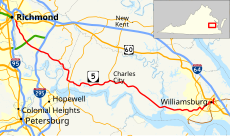
Category:Virginia State Route 5
Jump to navigation
Jump to search
 | number: | (five) |
|---|---|---|
| State highways in Virginia: | 2 · 3 · 4 · 5 · 6 · 7 · 8 · 9 · 10 · 13 · 14 · 16 · 18 · 20 · 22 · 24 |
State highway in eastern Virginia, US | |||||
| Upload media | |||||
| Instance of | |||||
|---|---|---|---|---|---|
| Location | Virginia | ||||
| Transport network | |||||
| Owned by | |||||
| Maintained by | |||||
| Inception |
| ||||
| Length |
| ||||
| |||||
English: Media related to Virginia State Route 5
Media in category "Virginia State Route 5"
The following 10 files are in this category, out of 10 total.
-
Flooding at the Richmond Train Station (7790613766).jpg 5,550 × 4,350; 1.12 MB
-
Hardens driveway.jpg 6,016 × 4,000; 6.5 MB
-
Just southeast of Charles City CH, former school.jpg 6,016 × 4,000; 6.35 MB
-
Northeast corner 25th and Broad streets (3595197339).jpg 750 × 587; 92 KB
-
VA 5 map.svg 1,205 × 709; 925 KB
-
VARte5.jpg 2,048 × 1,536; 774 KB
-
Virginia 5 (1918).svg 1,032 × 1,133; 258 KB
-
Virginia 5 (1956).svg 600 × 600; 3 KB
-
Virginia 5.svg 600 × 600; 3 KB


