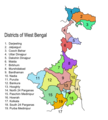
Category:Locator maps of districts of West Bengal
Jump to navigation
Jump to search
Subcategories
This category has the following 3 subcategories, out of 3 total.
!
D
- Locator maps of Darjeeling (10 F)
Media in category "Locator maps of districts of West Bengal"
The following 11 files are in this category, out of 11 total.
-
Alipurduar District.png 800 × 1,132; 108 KB
-
Bankura district.png 287 × 441; 38 KB
-
Birbhum district.png 287 × 441; 25 KB
-
Coochbehar district.png 287 × 441; 38 KB
-
Cooch Behar district.png 800 × 1,132; 119 KB
-
Darjeeling district.png 287 × 441; 37 KB
-
Darjeeling District Map.png 435 × 660; 23 KB
-
Jalpaiguri district.png 287 × 441; 37 KB
-
South dinajpur district.png 287 × 441; 37 KB
-
WestBengalDistricts numbered ml.svg 576 × 601; 146 KB
-
WestBengalDistrictscurrent.png 450 × 500; 69 KB


