Category:Kraftwerk Hagneck
Jump to navigation
Jump to search
| Object location | | View all coordinates using: OpenStreetMap |
|---|
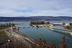
river power station and weir in Hagneck in the canton of Bern, Switzerland | |||||
| Upload media | |||||
| Instance of | |||||
|---|---|---|---|---|---|
| Part of | |||||
| Location | Hagneck, Seeland administrative district, Seeland administrative region, Bern, Switzerland | ||||
| Located in or next to body of water | |||||
| Street address |
| ||||
| Heritage designation |
| ||||
| Service entry |
| ||||
| Elevation above sea level |
| ||||
| official website | |||||
 | |||||
Media in category "Kraftwerk Hagneck"
The following 30 files are in this category, out of 30 total.
-
ETH-BIB-Elektrizitätswerk Hagneck, Bielersee-LBS H1-021098.tif 6,106 × 4,339; 75.85 MB
-
ETH-BIB-Elektrizitätswerk Hagneck, Bielersee-LBS H1-021099.tif 6,152 × 4,335; 76.35 MB
-
ETH-BIB-Hagneck, E.W. Hagneck-LBS H1-016946 cropped.tif 3,888 × 2,715; 30.22 MB
-
ETH-BIB-Hagneck, E.W. Hagneck-LBS H1-016946.tif 6,491 × 4,533; 84.32 MB
-
ETH-BIB-Hagneck, E.W.Hagneck-LBS H1-016945.tif 6,504 × 4,531; 84.43 MB
-
ETH-BIB-Hagneck, Elektrizitätswerk-Inlandflüge-LBS MH03-1233.tif 5,796 × 4,752; 78.81 MB
-
ETH-BIB-Hagneck, Elektrizitätswerk-Inlandflüge-LBS MH03-1234.tif 6,749 × 4,874; 94.12 MB
-
ETH-BIB-Hagneck, Elektrizitätswerk-Inlandflüge-LBS MH03-1235.tif 6,746 × 4,873; 94.06 MB
-
ETH-BIB-Hagneck-LBS H1-027906.tif 6,667 × 4,655; 88.83 MB
-
Hagneck Kraftwerk (1).jpg 6,000 × 4,000; 12.46 MB
-
Hagneck Kraftwerk (2).jpg 5,742 × 3,828; 11.74 MB
-
Hagneck Kraftwerk (3).jpg 6,000 × 4,000; 8.93 MB
-
Hagneckdelta von Nordwesten.jpg 3,005 × 1,935; 1.51 MB
-
Hagneckkanal bei Hagneck.JPG 2,592 × 1,944; 2.25 MB
-
Hagneckkanal Chasseral 02 12.jpg 1,575 × 1,049; 848 KB
-
I09 329 Kraftwerk Hagneck.jpg 4,494 × 2,996; 2.87 MB
-
I09 330 Staustufe Hagneck.jpg 4,328 × 2,885; 2.58 MB
-
I09 331 Staustufe Hagneck.jpg 4,248 × 2,832; 3.02 MB
-
Kraftwerk Hagneck 1-Oberwasserbrücke über den Hagneckkanal, Hagneck BE 20240827-jag9889.jpg 4,608 × 3,456; 9.16 MB
-
Kraftwerk Hagneck 1-Unterwasserbrücke über den Hagneckkanal, Hagneck BE 20240827-jag9889.jpg 4,608 × 3,456; 9.05 MB
-
Kraftwerk Hagneck 2-Wehrbrücke über den Hagneckkanal, Hagneck BE 20240827-jag9889.jpg 4,608 × 2,592; 8.14 MB
-
Kraftwerk Hagneck Maschinenhaus.jpg 3,000 × 2,000; 1.26 MB
-
Kraftwerk Hagneck-Brücke über den Hagneckkanal (Aare), Hagneck BE 20240827-jag9889.jpg 4,608 × 3,456; 9.24 MB
-
Kraftwerk Hagneck-Brücke über den Hagneckkanal, Hagneck BE 20240827-jag9889.jpg 4,608 × 2,592; 6.65 MB
-
Kraftwerk Hagneck.jpg 4,032 × 3,024; 2.24 MB
-
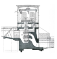
KW Hagneck, Schnitt durch Zentrale.png 546 × 565; 283 KB


