Category:Heart of Wessex Line
Jump to navigation
Jump to search
Railway line in England | |||||
| Upload media | |||||
| Instance of | |||||
|---|---|---|---|---|---|
| Part of |
| ||||
| Location | |||||
| Owned by | |||||
| Terminus | |||||
| |||||
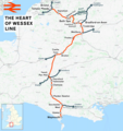
English: The Heart of Wessex Line is a railway line in England that runs from Bristol Temple Meads to Weymouth via Bath Spa, Westbury, Castle Cary, Yeovil Pen Mill and Dorchester West.
Subcategories
This category has the following 27 subcategories, out of 27 total.
A
- Avoncliff railway station (16 F)
B
- Bruton railway station (13 F)
C
- Chetnole railway station (14 F)
D
E
- Evershot railway station (1 F)
- Evershot Tunnel (2 F)
F
- Fairwood Junction (14 F)
- Frome railway station (48 F)
G
- Grimstone Viaduct (6 F)
K
M
O
R
- Radipole railway station (5 F)
T
U
W
Y
- Yetminster railway station (22 F)
Media in category "Heart of Wessex Line"
The following 46 files are in this category, out of 46 total.
-
GWR main line cut off routes.png 960 × 480; 66 KB
-
Heart of Wessex Line.png 2,382 × 2,537; 3.52 MB
-
Yeovil 1860 after LSW.gif 951 × 955; 45 KB
-
Yeovil railways.png 960 × 720; 46 KB
-
Bartonhill.jpg 640 × 426; 112 KB
-
Bath MMB 22 Bathampton Junction.jpg 3,821 × 2,397; 3.24 MB
-
Between Westbury and Frome - geograph.org.uk - 818441.jpg 640 × 466; 97 KB
-
Bradford Abbas intersection bridge (2019).JPG 1,366 × 910; 443 KB
-
Bristol MMB B8.jpg 2,304 × 1,728; 1.89 MB
-
Bristol MMB B9 Feeder Canal.jpg 2,304 × 1,728; 1.69 MB
-
Bristol MMB «56 Feeder Road.jpg 2,400 × 1,600; 953 KB
-
Bristol MMB «57 Feeder Road.jpg 2,400 × 1,600; 870 KB
-
Bristol MMB «59 Silverthorne Lane.jpg 2,227 × 1,402; 1.43 MB
-
Bristol MMB «60 Silverthorne Lane.jpg 2,400 × 1,600; 1.94 MB
-
Bristol MMB «H3 Bristol East Junction 43098.jpg 3,805 × 2,438; 2.56 MB
-
Bristol MMB «H4 Bristol East Junction 43098.jpg 3,852 × 2,496; 2.56 MB
-
Bristol MMB «H5 Dr Days Bridge Junction.jpg 3,764 × 2,438; 3 MB
-
Bristol MMB «I3 Bristol East Junction 43122.jpg 3,651 × 2,328; 2.61 MB
-
Bristol MMB «I4 Bristol East Junction 43122.jpg 3,681 × 2,277; 2.3 MB
-
Bristol MMB «I5 Bristol East Junction 43122.jpg 3,795 × 2,367; 2.61 MB
-
Bristol MMB «M6 Bristol East Junction.jpg 4,119 × 2,367; 3.48 MB
-
Bristol MMB «M7 Bristol East Junction.jpg 3,927 × 2,256; 3.73 MB
-
Bristol MMB «M8 Bristol East Junction 43304.jpg 4,056 × 2,394; 3.72 MB
-
Bristol MMB «Q6 Feeder Bridge Junction.jpg 3,187 × 2,295; 3.45 MB
-
Damers Road - geograph.org.uk - 381982.jpg 640 × 427; 109 KB
-
Dorchester to Yeovil Railway - geograph.org.uk - 1118873.jpg 640 × 428; 91 KB
-
Flooded Road near Bradford Peverell - geograph.org.uk - 1158981.jpg 640 × 449; 68 KB
-
Flooded Road near Stratton - geograph.org.uk - 1158980.jpg 640 × 425; 81 KB
-
Frome North Junction looking towards Frome station in 2015.JPG 1,366 × 1,024; 497 KB
-
Heart of Wessex Line - geograph.org.uk - 6511447.jpg 1,024 × 681; 226 KB
-
Heart of Wessex Line - geograph.org.uk - 6511450.jpg 1,024 × 681; 276 KB
-
On the Frome rail bypass - geograph.org.uk - 1774609.jpg 640 × 389; 88 KB
-
Poundbury, Frome Valley - geograph.org.uk - 1490719.jpg 640 × 480; 82 KB
-
Poundbury, railway bridge - geograph.org.uk - 1490488.jpg 640 × 480; 65 KB
-
Railway at Avoncliff - geograph.org.uk - 601371.jpg 640 × 435; 123 KB
-
Railway Bridge southeast of Maiden Newton - geograph.org.uk - 405731.jpg 640 × 480; 184 KB
-
Railway Cutting, Frampton - geograph.org.uk - 895193.jpg 477 × 640; 137 KB
-
Railway cutting, Frampton - geograph.org.uk - 895194.jpg 640 × 426; 99 KB
-
Railway track at Grimstone - geograph.org.uk - 1046513.jpg 640 × 428; 117 KB
-
River Frome in flood. - geograph.org.uk - 655193.jpg 640 × 427; 72 KB
-
The Westbury bypass - geograph.org.uk - 807358.jpg 640 × 501; 90 KB
-
The Westbury bypass line (2) - geograph.org.uk - 818497.jpg 640 × 450; 98 KB
-
The Westbury bypass line - geograph.org.uk - 818481.jpg 593 × 640; 116 KB
-
Track to Hog Cliff Bottom - geograph.org.uk - 1209370.jpg 640 × 439; 87 KB
-
Yeovil to Dorchester railway line - geograph.org.uk - 438728.jpg 477 × 640; 106 KB


