Category:German-language maps of Europe
Jump to navigation
Jump to search
Subcategories
This category has the following 26 subcategories, out of 26 total.
Media in category "German-language maps of Europe"
The following 52 files are in this category, out of 52 total.
-
1544 biarm.jpg 800 × 603; 120 KB
-
1804 Jeffreys and Kitchin Map of Ireland - Geographicus - Ireland-weimar-1804.jpg 4,000 × 4,789; 6.55 MB
-
1846 map - Europa nach seinen kirchlichen Verhältnissen.jpg 7,014 × 5,836; 16.75 MB
-
1916 map - Flemmings U-Boot-Kriegskarte von Europa.tif 10,149 × 8,200; 34.42 MB
-
Alemannischer Sprachraum.png 195 × 225; 5 KB
-
Carteeuropa.jpg 500 × 552; 582 KB
-
Das heutige Europa.pdf 3,279 × 2,468; 6.77 MB
-
Das Neue Europa Mit Dem Dauernden Frieden. Die Unionisierung Mitteleuropas.jpg 8,578 × 6,229; 12.4 MB
-
Dresden und Sächsische Schweiz (Storm Reiseführer, 1924) Seite 237.jpg 1,669 × 1,169; 1.05 MB
-
Dvorec Globelo na zemljevidu iz leta.jpg 1,280 × 989; 1.11 MB
-
Eickstedt.jpg 1,034 × 819; 185 KB
-
Eisenbahn-und Dampfschiffrouten-Karte von Europa - bearbeitet von J. Franz - btv1b530326952.jpg 21,463 × 16,476; 54.4 MB
-
Eisenbahn-und Dampfschiffrouten-Karte von Europa.jpg 21,463 × 16,476; 56.87 MB
-
Europa (14540242110).jpg 2,000 × 1,668; 4 MB
-
Europa 1828.JPG 4,860 × 3,654; 4 MB
-
Europe capitals map de.png 1,475 × 1,200; 1.16 MB
-
Europe countries map de.png 1,475 × 1,200; 609 KB
-
Europe geographique grande.jpg 1,050 × 828; 271 KB
-
Europe religion map de.png 1,475 × 1,200; 1.07 MB
-
Europe time zones map de.png 1,475 × 1,200; 986 KB
-
Europrobe - Avalonia Basement Europe.png 1,283 × 1,317; 53 KB
-
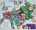
Europäische Keilerei 1914.jpg 4,133 × 3,479; 3.31 MB
-
Europäische Staaten.jpg 1,170 × 999; 363 KB
-
Europäische Treibjagd.jpg 3,773 × 3,302; 2.75 MB
-
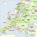
Europäische Wasserscheiden.png 1,200 × 1,184; 526 KB
-
Grossgliederung Europas.png 1,896 × 1,968; 1.71 MB
-
Humoristische Karte von Europa im Jahre 1914.tif 7,936 × 5,562; 126.31 MB
-
Imperial German naval bases.svg 976 × 818; 787 KB
-
Karte Donau.png 806 × 726; 426 KB
-
Karte Europäisches Nordmeer.png 1,000 × 913; 291 KB
-
Komische karte des Kriegsschauplatzes LCCN2003688898.jpg 8,519 × 6,138; 8.04 MB
-
Komische karte des Kriegsschauplatzes LCCN2003688898.tif 8,519 × 6,138; 149.63 MB
-
Land- und Seekarte des mittelländischen Meeres.jpg 22,031 × 10,217; 35.52 MB
-
Lange diercke sachsen europa bodenbenutzung.jpg 1,248 × 1,589; 883 KB
-
Map of Europe 2007 (political) de.png 1,596 × 1,043; 109 KB
-
Map of Western Europe in 1791 by Reilly 0006.jpg 1,470 × 952; 591 KB
-
Mitteleuropa – Konfessionsgebiete 1904.jpg 5,755 × 4,145; 15.12 MB
-
Mitteleuropäisches Tiefland.jpg 417 × 255; 34 KB
-
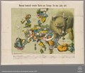
Neueste komisch-ernste Karte von Europa für das Jahr 1877.pdf 3,743 × 3,204; 7.39 MB
-
Old german map France, Spain and Portugal.jpg 944 × 1,446; 521 KB
-
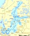
Ostseegliederung.png 871 × 1,039; 80 KB
-
Saidschitz, Sedlitz, Kollosoruk and laboratorium.png 1,093 × 682; 2.03 MB
-
SolarGIS-Solar-map-Europe-de.png 1,000 × 706; 685 KB
-
Streptopelia decaocto expansion.png 2,388 × 2,361; 2.44 MB
-
Template europe map de.png 1,475 × 1,200; 571 KB
-
Westermanns Neuer Schulatlas 1928 (14-15) Mitteleuropa.jpg 8,982 × 6,684; 22.12 MB
-
Westermanns Neuer Schulatlas 1928 (22-23) Europa, Geländekarte, Klima und Exporte.jpg 9,012 × 6,653; 22.27 MB
-
Westermanns Neuer Schulatlas 1928 (24) Europa, Staaten.jpg 4,526 × 6,681; 10.05 MB
-
Westermanns Neuer Schulatlas 1928 (25) Europa, Religionen und Völker.jpg 4,503 × 6,642; 8.59 MB


