Category:Geological maps of Florida
Jump to navigation
Jump to search
States of the United States: Alabama · Alaska · Arizona · Arkansas · California · Colorado · Connecticut · Delaware · Florida · Georgia · Hawaii · Idaho · Illinois · Indiana · Iowa · Kansas · Kentucky · Louisiana · Maine · Maryland · Massachusetts · Michigan · Minnesota · Mississippi · Missouri · Montana · Nebraska · Nevada · New Hampshire · New Jersey · New Mexico · New York · North Carolina · North Dakota · Ohio · Oklahoma · Oregon · Pennsylvania · Rhode Island · South Carolina · South Dakota · Tennessee · Texas · Utah · Vermont · Virginia · Washington · West Virginia · Wisconsin · Wyoming
Puerto Rico
Puerto Rico
Subcategories
This category has the following 5 subcategories, out of 5 total.
Media in category "Geological maps of Florida"
The following 45 files are in this category, out of 45 total.
-
-
 Brevard County, Florida - soil interpretive map of soil drainage and water table depths LOC 81690353.tif 5,919 × 11,453; 193.95 MB
-
 Chipola Subsea Florida Burdigalian-Langhian.png 607 × 600; 45 KB
-
 Cody Scarp extent.png 808 × 800; 201 KB
-
 Coharie Leon County Florida01.png 694 × 450; 48 KB
-
 DeSoto Plain Florida location map.png 908 × 900; 229 KB
-
 Early Miocene Florida Burdigian.png 887 × 900; 311 KB
-
 Early Miocene Florida-Rupelian.png 887 × 900; 391 KB
-
 Eocene Orange Island.png 606 × 600; 110 KB
-

-

-
 Everglades Geology.png 450 × 662; 62 KB
-
 Florida 10000 years ago.png 522 × 550; 149 KB
-
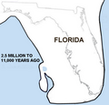 Florida 2.5 m.png 499 × 480; 89 KB
-
 Florida 2.5m.png 572 × 550; 185 KB
-
 Florida 2.5mya.png 572 × 550; 196 KB
-
 Florida 6000 years ago.png 610 × 600; 122 KB
-
 Florida 8000 years ago.png 587 × 600; 169 KB
-
 Florida Early Miocene.png 605 × 600; 151 KB
-
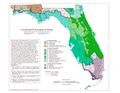 Florida EPA level IV ecoregions map.pdf 1,650 × 1,275; 818 KB
-
 Florida Peninsular Arch.png 616 × 600; 31 KB
-
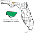 Gadsden County Florida exploding 600px.png 624 × 600; 104 KB
-
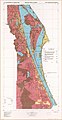
 Geologic map of Florida - by C. Wythe Cooke - btv1b53189547r.jpg 7,580 × 10,058; 9.21 MB
-
 Gulf Trough.png 448 × 500; 63 KB
-
 Hazelhurst-Florida-geology.png 1,182 × 1,200; 525 KB
-

-
 Jackson Subsea Florida Pliocene-Pleistocene.png 611 × 600; 57 KB
-
 Late Pliocene Florida.png 887 × 900; 301 KB
-
 Leon County Florida geological.png 741 × 580; 198 KB
-

-

-
 Miocene Florida Burdi Langhian.png 608 × 600; 131 KB
-
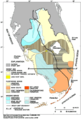
 NPS big-cypress-geologic-map.gif 2,468 × 2,844; 776 KB
-
 NPS everglades-geologic-map.jpg 4,000 × 4,604; 4.43 MB
-
 Ocala Platform map 600.png 624 × 600; 95 KB
-
 Okeechobee Plain location map.png 908 × 900; 220 KB
-
 Okefenokee Leon County Florida.png 704 × 450; 62 KB
-
 Penholoway Leon County Florida.png 692 × 450; 40 KB
-
 Polk County Florida exploding 550px.png 555 × 550; 84 KB
-

-

-
 Talbot Leon County Florida.png 646 × 420; 34 KB
-
 Tamiami Subsea map.png 560 × 550; 175 KB
-
 Wakulla Springs Flow Rate G056.jpg 664 × 858; 120 KB
-
 Wicomico Leon County Florida.png 686 × 450; 36 KB


