Category:Durham Coast Line
Jump to navigation
Jump to search
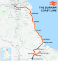
English: The Durham Coast Line (DCL) is the name given to the railway services which link Newcastle upon Tyne with Middlesbrough, via Sunderland and Hartlepool. The services are operated by Northern Rail (who took over the franchise from Arriva Trains Northern in December 2004).
A Railway Line in North East England | |||||
| Upload media | |||||
| Instance of | |||||
|---|---|---|---|---|---|
| Part of |
| ||||
| Location | North East England, England | ||||
| Owned by | |||||
| Operator | |||||
| Date of official opening |
| ||||
| |||||
Subcategories
This category has the following 25 subcategories, out of 25 total.
B
- Billingham railway station (11 F)
C
- Crimdon Dene Viaduct (7 F)
D
- Denemouth Railway Viaduct (12 F)
E
G
- Greatham railway station (3 F)
H
- Hart railway station (6 F)
- Hawthorn Dene Viaduct (15 F)
- Heworth railway station (5 F)
- Horden railway station (24 F)
M
- Monkwearmouth Railway Bridge (25 F)
N
S
- Seaham railway station (12 F)
T
W
- West Hartlepool engine shed (10 F)
Media in category "Durham Coast Line"
The following 64 files are in this category, out of 64 total.
-
Durham Coast Line.png 1,481 × 1,550; 1.42 MB
-
Blackhall Rocks MMB 01.jpg 4,736 × 2,676; 3.47 MB
-
Boldon West Junction.jpg 1,600 × 1,200; 867 KB
-
Bridge on the Durham Coast Line near Easington Colliery. 24 02 2021.jpg 4,032 × 1,960; 3.63 MB
-
Bridge under Durham Coastal Railway.jpg 640 × 480; 83 KB
-
Buckled Railway Lines (5757845999).jpg 792 × 527; 128 KB
-
Burned out Cart and Railway (5757845975).jpg 978 × 615; 121 KB
-
Coastal railway heading north - geograph.org.uk - 3219068.jpg 640 × 474; 90 KB
-
Coastal railway heading north towards Sunderland (geograph 2703596).jpg 640 × 480; 106 KB
-
Damaged Rolling Stock (5757845997).jpg 1,157 × 824; 148 KB
-
Disused railway, Grangetown - view north - geograph.org.uk - 1530408.jpg 640 × 480; 112 KB
-
Durham Coast Line passing Gateshead 2005-10-10.jpg 1,600 × 1,200; 878 KB
-
Durham Coast Line, Acacia Avenue bridge, Horden 3. 17 07 2017.jpg 5,184 × 3,456; 9.01 MB
-
Durham Coast Line, brige over Cotsford Lane, Horden. 17 07 2017.jpg 5,184 × 3,456; 9.64 MB
-
Durham Coast Line, Denemouth Railway Viaduct 2. 17 07 2017.jpg 3,456 × 5,184; 7.59 MB
-
Durham Coast Line, Hall Dene Level Crossing 3. 28 07 2017.jpg 5,184 × 3,456; 8.83 MB
-
Durham Coast Line, north of Hall Dene Level Crossing. 28 07 2017.jpg 5,184 × 3,456; 9.74 MB
-
Durham Coast Line, south of Hall Dene Level Crossing. 28 07 2017.jpg 5,184 × 3,456; 9.07 MB
-
Durham Coast Line, south of Seaham 1. 28 07 2017.jpg 5,184 × 3,456; 7.7 MB
-
Durham Coast Line, south of Seaham 2. 28 07 2017.jpg 5,184 × 3,456; 7.68 MB
-
Durham Coast Line, Spectrum Business Park. 28 07 2017.jpg 5,184 × 3,456; 8.03 MB
-
East Boldon station 01.jpg 1,600 × 1,200; 846 KB
-
East Coast Rail Line - geograph.org.uk - 1376906.jpg 640 × 480; 73 KB
-
Extension Street Railway Bridge - geograph.org.uk - 87569.jpg 640 × 480; 95 KB
-
Fellgate station 01.jpg 1,600 × 1,200; 866 KB
-
Fellgate station 02.jpg 1,600 × 1,200; 872 KB
-
Felling station 01.jpg 1,600 × 1,200; 972 KB
-
Felling station 02.jpg 1,600 × 1,200; 819 KB
-
Firefighters battling the blaze. (5757521389).jpg 828 × 516; 94 KB
-
Footpath steps - geograph.org.uk - 1358221.jpg 640 × 480; 136 KB
-
Greatham Signal Box near Hartlepool - geograph.org.uk - 1576444.jpg 640 × 578; 100 KB
-
Hawthorn Beach Showing Viaduct - geograph.org.uk - 983186.jpg 640 × 480; 115 KB
-
Hawthorn Dene footpath - geograph.org.uk - 1333278.jpg 640 × 480; 166 KB
-
Hills Street Railway Bridge - geograph.org.uk - 200655.jpg 640 × 480; 77 KB
-
Lines south of Seaburn Metro station - geograph.org.uk - 4121889.jpg 640 × 480; 143 KB
-
Norton railway station (site), County Durham (geograph 4299843).jpg 1,600 × 1,200; 315 KB
-
Pelaw Metro Junction 1.jpg 1,600 × 1,200; 865 KB
-
Pelaw Railway Lines - geograph.org.uk - 201797.jpg 640 × 480; 94 KB
-
Pipe Carriers - geograph.org.uk - 309573.jpg 640 × 384; 51 KB
-
Railway above Hawthorn Hive - geograph.org.uk - 320083.jpg 640 × 480; 136 KB
-
Railway Bridge LEN3 - 286 - geograph.org.uk - 1802499.jpg 640 × 480; 78 KB
-
Railway bridge near Ragworth - geograph.org.uk - 1750027.jpg 3,088 × 2,056; 2.64 MB
-
Railway bridge over Ropery Walk, Seaham (geograph 3219049).jpg 640 × 480; 63 KB
-
Railway heading north - geograph.org.uk - 3219515.jpg 640 × 480; 108 KB
-
Railway Junction - geograph.org.uk - 985709.jpg 640 × 427; 247 KB
-
Railway Line and Industrial Estate - geograph.org.uk - 309597.jpg 640 × 426; 87 KB
-
Railway line south of Seaham - geograph.org.uk - 821073.jpg 640 × 480; 95 KB
-
Railway lines near Powlett Road - geograph.org.uk - 315084.jpg 640 × 480; 91 KB
-
Railway to Hartlepool - geograph.org.uk - 982719.jpg 640 × 427; 298 KB
-
Railway tracks near Cowpen Bewley - geograph.org.uk - 1806261.jpg 3,088 × 2,056; 3.32 MB
-
Seaburn Metro station 01.jpg 1,600 × 1,200; 952 KB
-
Site of the sidings serving Easington Colliery. 24 02 2021.jpg 4,032 × 1,960; 2.06 MB
-
Stadium of Light Metro station 01.jpg 1,600 × 1,200; 980 KB
-
Timber Alight Behind the Railway Lines (5757679991).jpg 1,152 × 808; 208 KB
-
Tyne and Wear Metro and National Rail track between Felling and Heworth.jpg 1,600 × 1,200; 867 KB
-
Tyne and Wear Metro and National Rail track between Heworth and Pelaw.jpg 1,600 × 1,200; 886 KB
-
West Hartlepool dock map.jpg 2,012 × 3,102; 1.65 MB


