Category:Disused railway lines in Devon
Jump to navigation
Jump to search
Subcategories
This category has the following 33 subcategories, out of 33 total.
B
- Black Bridge (Burlescombe) (9 F)
C
D
E
H
- Haytor Granite Tramway (71 F)
I
K
L
- Laira railway bridge (30 F)
- Lundy Quarry tramway (4 F)
M
N
O
P
S
- Shaugh Tunnel (8 F)
- Stonehouse Pool Viaduct (5 F)
T
Y
Z
- Zeal Tor Tramway (17 F)
Media in category "Disused railway lines in Devon"
The following 122 files are in this category, out of 122 total.
-

-

-
 Along The Hatshill Wood Viaduct - geograph.org.uk - 883256.jpg 640 × 427; 119 KB
-

-

-

-
 Bridge at Sourton - geograph.org.uk - 596486.jpg 640 × 480; 99 KB
-
 Bridge on old railway line crosses road - geograph.org.uk - 1000445.jpg 480 × 640; 104 KB
-
 Bridge on the Tarka Trail - geograph.org.uk - 995958.jpg 640 × 480; 114 KB
-
 Bridge over cycleway 2 - geograph.org.uk - 1111469.jpg 640 × 430; 87 KB
-
 Bridge over dismantled railway - geograph.org.uk - 1048080.jpg 640 × 427; 146 KB
-
 Bridge over disused railway, Trusham - geograph.org.uk - 1215543.jpg 640 × 480; 101 KB
-

-
 Bridge over railway line at Cann Quarry.jpg 4,016 × 2,848; 7.52 MB
-
 Bridge over the Old Railway Line - geograph.org.uk - 883052.jpg 640 × 427; 160 KB
-
 Bridge over the River Plym (2865415039).jpg 2,112 × 2,816; 3.85 MB
-
 Bridge over the River Plym (2865428489).jpg 2,112 × 2,816; 3.21 MB
-
 Bridge over the River Plym (2866264578).jpg 2,724 × 2,020; 4.11 MB
-
 Bridge over the Tarka Trail - geograph.org.uk - 1360743.jpg 640 × 480; 117 KB
-

-

-

-

-
 Budleigh Salterton cycle path - geograph.org.uk - 1139466.jpg 640 × 427; 174 KB
-
 Cann Viaduct.jpg 4,256 × 2,848; 4.81 MB
-

-
 Castle lane 880m, Cycleway 2 - geograph.org.uk - 1111841.jpg 640 × 430; 101 KB
-
 Course of dismantled railway, Bickham - geograph.org.uk - 1048901.jpg 640 × 427; 144 KB
-
 Cycle track in plymbridge woods - panoramio.jpg 3,264 × 2,448; 2.75 MB
-
 Cycleway 2 near Bradham Lane - geograph.org.uk - 1111480.jpg 640 × 430; 94 KB
-

-
 Cyclist on the Tarka Trail - geograph.org.uk - 1331542.jpg 640 × 480; 164 KB
-
 Cyleway from the Road Bridge - geograph.org.uk - 884391.jpg 427 × 640; 146 KB
-
 Demolished railway bridge. - geograph.org.uk - 933803.jpg 640 × 480; 147 KB
-
 Derriton Railway Viaduct.jpg 640 × 412; 52 KB
-
 Devon Great Consols Railway.jpg 4,056 × 2,848; 3.75 MB
-
 Dismantled bridge - geograph.org.uk - 1365966.jpg 640 × 428; 103 KB
-
 Dismantled Tramway - geograph.org.uk - 1365951.jpg 640 × 428; 146 KB
-
 Disused railway at Teigngrace - geograph.org.uk - 1371749.jpg 640 × 480; 296 KB
-
 Disused Railway Bridge - geograph.org.uk - 683010.jpg 640 × 427; 323 KB
-
 Disused railway bridge - geograph.org.uk - 919495.jpg 640 × 425; 120 KB
-
 Disused Railway Bridge near Whitchurch - geograph.org.uk - 505225.jpg 640 × 480; 157 KB
-
 Disused railway bridge over the Avon - geograph.org.uk - 1048910.jpg 640 × 427; 156 KB
-
 Disused railway bridge, near Exbridge - geograph.org.uk - 1765171.jpg 1,600 × 1,200; 677 KB
-
 Disused railway bridge, Wheal Emma, 1979 - geograph.org.uk - 65011.jpg 640 × 460; 106 KB
-
 Disused railway line at Instow - geograph.org.uk - 1355640.jpg 640 × 480; 111 KB
-

-

-
-

-

-

-
 Exposed rock in cutting on disused railway at Landcross (geograph 4323589).jpg 1,600 × 1,200; 2.16 MB
-
 Fitzroy Road (505684431).jpg 2,000 × 1,500; 3.21 MB
-
 Fitzroy Road (505691359).jpg 2,000 × 1,500; 3.22 MB
-
 Following the line (505682679).jpg 2,000 × 1,500; 3.22 MB
-

-
 Gradient post on the Tarka Trail - geograph.org.uk - 1360709.jpg 640 × 480; 93 KB
-
 Gradient Post on the Tarka Trail - geograph.org.uk - 1554129.jpg 640 × 480; 71 KB
-
 Ham Bridge (geograph 2439711).jpg 2,431 × 1,580; 4.36 MB
-

-
 Horsebrook Cottages, Avonwick - geograph.org.uk - 1066401.jpg 640 × 427; 99 KB
-
 Horses and bridge at Meldon - geograph.org.uk - 595864.jpg 464 × 640; 106 KB
-
 Laira Bridge Plymouth, UK.jpg 3,968 × 2,968; 4.52 MB
-
 Laira Railway Bridge - geograph.org.uk - 1258529.jpg 640 × 421; 78 KB
-
 Laira Railway Bridge - geograph.org.uk - 1555849.jpg 640 × 480; 98 KB
-
 Landcross tunnel.jpg 3,728 × 2,668; 6.02 MB
-
 Lustleigh, Dismantled railway line - geograph.org.uk - 436449.jpg 640 × 480; 169 KB
-
 Meavy, inclined plane - geograph.org.uk - 653515.jpg 640 × 427; 233 KB
-
 Molesworth Road (506468233).jpg 1,970 × 1,470; 3.65 MB
-
 Morwellham Quay - geograph.org.uk - 411788.jpg 480 × 640; 210 KB
-
 Old Laira Railway Bridge.JPG 2,263 × 1,415; 1.18 MB
-
 Old Level Crossing Gate near Cadhay - geograph.org.uk - 1030851.jpg 640 × 351; 54 KB
-

-
 Old Railway Bridge at Kersbrook - geograph.org.uk - 956794.jpg 640 × 480; 126 KB
-
 Old railway bridge over the River Avon - geograph.org.uk - 1562303.jpg 640 × 480; 141 KB
-

-
 Old railway path? (2866249770).jpg 2,112 × 2,816; 3.85 MB
-
 Old railway path? (2866270404).jpg 2,112 × 2,816; 3.91 MB
-
 Old railway tracks in Braunton - geograph.org.uk - 5117842.jpg 1,600 × 1,067; 619 KB
-
 On the Cycleway - geograph.org.uk - 883090.jpg 498 × 640; 178 KB
-
 On the Tarka Trail - geograph.org.uk - 1345469.jpg 640 × 480; 183 KB
-
 Overgrown railway track - geograph.org.uk - 994605.jpg 640 × 427; 106 KB
-
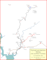 P&DR map after Lee Moor.gif 3,354 × 4,354; 318 KB
-
-
 Path that used to be a railway - geograph.org.uk - 919549.jpg 480 × 640; 186 KB
-
 Path, Tiverton - geograph.org.uk - 1397859.jpg 480 × 640; 116 KB
-
 Paviland Grange (506436000).jpg 2,000 × 1,500; 3.29 MB
-
 Picnic Table by Cycleway 2 - geograph.org.uk - 1111847.jpg 640 × 430; 108 KB
-
 Points - old railway track - geograph.org.uk - 15207.jpg 640 × 425; 154 KB
-
 Primrose Line in Woodleigh Wood - geograph.org.uk - 1297136.jpg 480 × 640; 159 KB
-

-
 Railway Bridge on Marsh Barton Road - geograph.org.uk - 1015944.jpg 640 × 480; 92 KB
-
 Railway bridge, Leigh Cross - geograph.org.uk - 798847.jpg 640 × 480; 107 KB
-
 Railway Bridge, Narracott - geograph.org.uk - 731440.jpg 640 × 499; 147 KB
-
 Railway bridge, near Knowle - geograph.org.uk - 1180703.jpg 640 × 480; 127 KB
-
 Railway Lines - geograph.org.uk - 934691.jpg 640 × 428; 121 KB
-
 Railway trackbed, near Higher Knowle - geograph.org.uk - 1224774.jpg 640 × 480; 137 KB
-

-
 Remains of old railway bridge - geograph.org.uk - 1579997.jpg 640 × 480; 81 KB
-

-
 Road Bridge over the Cycleway - geograph.org.uk - 884378.jpg 640 × 427; 147 KB
-
 Road bridge over the Tarka Trail - geograph.org.uk - 1359490.jpg 640 × 480; 110 KB
-
 Route of dismantled railway - geograph.org.uk - 1065155.jpg 640 × 480; 141 KB
-
 Route of dismantled railway - geograph.org.uk - 1065176.jpg 640 × 480; 137 KB
-
 Route of old Sidmouth railway line - geograph.org.uk - 1000442.jpg 640 × 480; 117 KB
-
 Seat at the side of Cycleway 2 - geograph.org.uk - 1111838.jpg 640 × 430; 120 KB
-
 Tarka Trail - geograph.org.uk - 1346681.jpg 640 × 480; 111 KB
-
 Tarka Trail approaching Taw Bridge - geograph.org.uk - 1349319.jpg 640 × 455; 89 KB
-
 Tarka Trail junction - geograph.org.uk - 567476.jpg 640 × 480; 150 KB
-
 Tarka Trail on Clay Moor.jpg 3,987 × 2,771; 5.4 MB
-
 Tarka Trail passing Landcross (geograph 4323581).jpg 1,600 × 1,200; 2 MB
-
 The Plym Valley Cycleway - geograph.org.uk - 883230.jpg 640 × 427; 161 KB
-
 The Tarka Trail near Ashford - geograph.org.uk - 1358031.jpg 640 × 480; 90 KB
-
 The Tarka Trail near Barnstaple - geograph.org.uk - 43080.jpg 640 × 427; 68 KB
-

-
 Track of GWR line to Foggintor Quarry - geograph.org.uk - 1394812.jpg 640 × 480; 252 KB
-
 Tunnel at Lucas Terrace Plymouth - geograph.org.uk - 998466.jpg 640 × 449; 85 KB
-
 Tunnel In Winter - panoramio.jpg 2,448 × 3,264; 1.05 MB
-

-

-


.jpg)
.jpg)
.jpg)


.jpg)
.jpg)
.jpg)
.jpg)


.jpg)


.jpg)


_over_Dalditch_Lane_-_geograph.org.uk_-_956783.jpg)


.jpg)
.jpg)


.jpg)


_north_of_Exbridge_-_geograph.org.uk_-_1534651.jpg)


.jpg)


